SATURDAY September 27, 2014
WEATHER: 50’s at night but warmed
up quick once the sun came up – high of 82.
Clouded up in the late afternoon but still warm.
TRAVEL: About 2.3 hrs from Baltimore to Dover – picked up my trailer (zero cost for storage) and almost 100 miles ( still 2 hours) from Dover to Cherry Hill RV Park in Cherry Hill, MD. Cherry Hill is a nice park – lots of amenities. WIFI works, a laundry, an orientation session for DC touring, a METRO bus stop in the park’s office, 2 pools, a restaurant, game room, exercise room – it’s also the most expensive park I’ve stayed at – about $10 per day over the nicest I’ve stayed at – it must be the area. I’m here until October 14th.
 |
| Cherry Hill Office |
 |
| Cherry Hill - trailer & truck |
SUNDAY – September 28, 2014
WEATHER: cool morning in the low
50’s up to the 80’s clear
TRAVEL: auto to church about 2 miles and travel to the parking ramp for the METRO COLLEGE PARK/U of MARYLAND. (Parking is free on Weekends, otherwise $5.10 per day. It can take the bus from the RV Park to the station for $.85 on way senior rate.) COLLEGE PARK/U of MARRYLAND to NAVY YARD/BALLPARK on the GREEN LINE was about a 35-40 minute one way ride. I’ll use the METRO and bus system as much as I can.
Did laundry early before church.
While waiting for loads of
laundry, I finished reading a small book (158 pages) entitled Stonewall Jackson’s 1862 Valley Campaign – War Comes to the
Homefront. The book is one of several written as part of
the Civil War Sesquicentennial Series. Authored by Jonathan A. Noyes, Assistant
Professor of History at Fairfax Community College in Middletown, VA it is well
written, researched and documented. He
tells the story of the Valley Campaign
succinctly and as much as possible from the viewpoint of the Shenandoah Valley citizens it
affected.
Interesting, Noyes paints Union Gen
Robert H. Milroy as an aggressive leader.
Quite the opposite of how Stephen
Sears refers to “Milroy’s Weary Boys”
in his book “Gettysburg.”
Like Robert E. Lee, Thomas J.
(Stonewall) Jackson is another ‘saint’ of the South. I never really understood the campaign and
personally believe Jackson is over-rated.
The Valley Campaign, an more
or less independent command, was his most memorable achievement – providing
hope to the South at a time when the South needed victories - before Robert E. Lee took command. Later Jackson
joined Lee on the peninsula and
didn’t appear to be as dynamic as l he was in the Valley. He did capture Harpers Ferry as directed by Lee during
Lee’s Maryland Campaign, joined Lee and Longstreet at Antietam,
could have done better at Fredericksburg
and was fatally wounded by friendly fire after his corps surprised the right
flank of Hooker’s Army of the Potomac, at Chancellorsville.
This is more for me to follow – you
may find it interesting - I’ll try to be brief:
March 23, 1862 – First
Battle of Kernstown. . . . because “in war things are not as they
seem,” both N & S claimed victory; a
tactical victory for the North; a strategic victory for the South. Jackson was to use the Valley as a
diversionary theatre of war in order to protect Richmond – keeps Federal troops
in the Valley rather than to reinforce McClellan’s
Peninsula Campaign and assault on Richmond. Jackson was outnumbered. The
War Dept redirected 20,000 troops to stay near Washington or in the Valley or
in Fredericksburg rather than aid McClellan.
“Jackson gave up the field repulsed,
but not vanquished, defeated, but not routed nor demoralized.”
NAMES in the Battle:
GEN Thomas J. Jackson, CSA COL Turner Ashby, CSA, Cavalry
GEN Thomas J. Jackson, CSA COL Turner Ashby, CSA, Cavalry
Gen Fulkerson, CSA Bde Cdr Gen Richard Garnett,
CSA, Bde Cdr
GEN James Shields USA (WIA) COL Nathan Kimball, USA, Bde Cdr, Cmd after
Shields
Gen Erastus Tyler, USA, Bde Cdr Gen Jeremiah Sullivan, USA Bde
Cdr
Some saw this battle as
diminishing the image of “Stonewall” won at Manassas.
May 8, 1862 – Battle of McDowell. . .
. after Kernstown, Jackson looked for reinforcements. Jed
Hotchkiss who served as a militia officer in the Valley was summoned to
join Jackson’s staff as ‘mapmaker.’ With
others added his army grew from about 3,000 to 6,000. Addtionally, GEN Edward “Alleghany” Johnson joined him
with 3,500 and GEN Richard Ewell’s Division also reported to Jackson. Jackson turned to face Union GEN John C. Fremont’s army of 20,000. The Battle
of McDowell pitted the advance Brigades of Gen Robert H. Milroy & Robert C. Schneck (about 3,500) against Jackson’s Brigades led by Genl’s W.C. Scott, William Taliaferro and Conner.
Here Jackson had the numbers advantage. Jackson’s
goal his was to keep Fremont from
linking up with GEN Nathanial Banks
in the Shenandoah Valley. As the outnumbered Union forces withdrew
Jackson followed in pursuit until Milroy
and Schneck found a defensive
position that Jackson thought best
not to attack. Jackson did not ‘crush’
but union force but succeeded in keeping it from joining Banks.
IF YOU”RE STILL WITH ME – GOOD
FOR YOU – THIS CAMPAIGN IS DIFFICULT TO FOLLOW – PROABABLY THAT’S WHY IT’S
TAKEN ME A LONG TIME TO EVEN TRY TO UNDERSTAND - I’VE TRIED TO SIMPLIFY –
HOPEFULLY . . . .
May 23, 1862 - FRONT
ROYAL - Lee now
in command of the Army of Virginia,
ordered Jackson to strike Gen Nathanial Banks immediately. Jackson
combined his forces with Gen Richard Ewell’s near New Market, VA. As the army approached New Market Gen Richard Taylor’s lead brigade was the only
brigade to march to the main valley – diversion – while Jackson and Ewell marched down the Luray
Valley to strike Banks left
flank at Front Royal – an important
supply depot.
COL Richard Ashby’s cavalry successfully disrupted Banks lines
of communication between Front Royal
and Strasburg. At Front
Royal the main union force was the 1st
Maryland (US) under the command of John
R. Kenly. Kenly could not win
against Jackson’s force but he could and delay Jackson’s advance. Kenly and the 1st Maryland (US) were defeated; most were captured.
May 25, 1862 - FIRST
WINCHESTER Banks column of 5,000 soldiers and 500 wagons
pulled back from Strasburg to Winchester on the Valley Pike. Jackson learned of Banks withdrawal through
Ashby’s cavalry reports. In effect Banks
was trapped and ambushed – Banks knew he was outnumbered but decided to stand
and fight a delaying action Two brigades of Banks faced 7 brigades of Jackson’s
– the result was inevitable. However,
again Jackson did not annihilate the enemy.
When the opportunity for follow-up
came the cavalry under Ashby was in disarray and could not turn the
victory into a complete rout.
June 6, 1862 – PORT
REPUBLIC Lincoln ordered GEN John C.
Fremont to move into the Shenandoah
Valley immediately in order to cut off Jackson from his supply base at Staunton. Fremont opted to march his army north
disobeying Lincoln’s order. On May 27 Fremont was at Moorefield and informed Lincoln of his location. Fremont made excuses . . . . He was
ordered to remain at Moorefield.
Simultaneously, Union Gen Shields Division marched toward the lower Shenandoah Valley. Shields occupied Front Royal. Jackson had to depart from Winchester and moved toward Strasburg past Fremont, who showed little
aggressiveness, and followed Jackson south.
Fremont was to the north following Jackson, Shields was to the east. Jackson decided to divide and conquer. As his army neared Port Republic, Ashby’s cavalry repulsed the attack of Union
cavalry COL
Sir Percy Wyndham’s 1st NJ Cavalry at Harrisonburg, however as the attack
continued with
Ashby leading the 1st MD (CS) and 58th VA, he
was KIA. The confederates beat back the
federals. Ashby became the Confederacy’s
first tragic war hero.
June 8, 1862 – CROSS
KEYS
Fremont ordered Milroy’s Brigade on a recon to Port Republic. Halfway
between Port Republic and Harrisonburg at Cross Keys he met troops from Gen
Ewell’s Division. Fremont skirmished but
did not bring on a general engagement as ordered by Fremont. In addition to Milroy, Fremont brought up 3
other brigades led by Schneck, Bohler, and Stahel. They faced brigades led by Steuart, Elzey and
Trimble. At the end of the day – there
were 700 federal casualties, Ewell suffered 300. Trimble was tenacious and wanted to launch a
night attack. However, Ewell would not give the order without Jackson’s
consent. The night gave Jackson the
ability to concentrate his army. The
confederates attacked in the morning. By
11 am Jackson had secured victory. The remainder of Fremont’s force arrived but they
were now separated by a river. Port
Republic and Cross Keys were union losses due to the “blundering of Shields and
the sluggishness of Fremont.”
 |
| St. Joseph's |
10:00 MASS at St. JOSEPH PARISH, Beltsville, MD. A relatively new church – almost full – must have been 250 people there. A younger parish – mix of Black, Hispanic, White some Asian – they must have had 50 kids file out for “children’s church.” A priest in his 30s/40’s – a Monsignor who appeared hip, gave the homily – asking for the archdiocesan appeal – a choir of about 10 voices but it also had a flutist, pianist, stand up bass, guitar and a guy on conga drums that gave the music a different feel/beat. All in all I appreciated the Baptist Chaplain’s homily last week – although the Monsignor was hip - - - - not overbearing – sincere – his appeal was short and simple.

 WASHINGTON
NATIONALS vs. MIAMI MARLINS
NATIONALS PARK
WASHINGTON
NATIONALS vs. MIAMI MARLINS
NATIONALS PARK
Section
135 Row S Seat 8. This
was the last game of the season and the Nationals had already tied up the
National League East Division Conference title several weeks ago. The closest contender was 16 games away. Nationals Park is in the SE section of
DC.
A Home Run by the Nationals in the 2nd
was the only run on 11 hits; the Marlins
had 0 runs and 0 hits. Except for the one home run - the pitchers did a good
job. It was the last game of the
regular season and the Nationals Center Fielder scored his 184th hit
- a club record – the fans were very enthusiastic. Too bad the beer vendors
were not – park is OK. It was in the
80s. They had a almost sellout
crowd. I had trouble finding a ticket
months ago. They averaged about 31,000
per game for the season..
MONDAY – September 29, 2014
WEATHER: a low around 60 – got up
to 74 – cloudy – some drizzle
TRAVEL: must have driven a triangle – 30 miles from Cherry Hill Park to Fort McHenry – 32 miles from Fort McHenry to the U.S. Naval Academy at Annapolis – 30 miles from the Academy to Cherry Hill.

I’d had first been to Fort McHenry in 2008. The
NGAUS Conference was in Baltimore and the Governor’s Reception was held
here. It was twilight, lots of food,
people, beverages . . . . the visit this
time, took about 2 ½ hours. There is a fee to enter the fort but the
grounds and Visitor Center are no charge.
There is a short film describing the Battle of Baltimore in the Visitor
Center.
The repulse of a
British naval attack against Fort
McHenry (War of 1812) prevented the capture of Baltimore and inspired Francis Scott Key to write “The Star Spangled Banner.”
Napolean was defeated in April 1814 and exiled to Elba. The British sent a force of veterans under
the command of MG Robert Ross (4,300 soldiers) and Vice Admiral Alexander Cochrane (4
ships of the line, 20 frigates, 20 transports) up Chesapeake Bay to give the
Americans “a complete drubbing.” They
had defeated the American Army at the Battle
of Bladensburg and burned Washington City.
Baltimore was next.
 |
| Fort McHenry |
The Americans at
Baltimore were under the command of MG Samuel Smith (a US Senator & veteran
of the Revolution). The force totaled
about 15,000 mostly MD, PA, and VA militia. They established a strong line of
defense.
 |
| Fort McHenry Gun Deck in front of fort |
Washington lawyer Francis Scott Key was detained by the
British ships as he was on a mission to free American Prisoners. He sought the release of a friend, arrested
for allegedly violating a pledge of good conduct after the Battle of Bladensburg. They
were detained because they had learned of the British plan to attack Baltimore.
 |
| Fort McHenry |
Admiral Cochrane began his attack of Fort
McHenry at dawn on September 13th.
The bombardment lasted 25 hours. Realizing
that Fort McHenry would never fall
by shell alone, he launched a diversionary attack of marines and sailors on a
night attack Fort McHenry by
land. It was unsuccessful. The men in the long boats became lost in the
night – they returned to the fleet. The
failure of this attack dashed British hopes of capturing Baltimore. They ceased the bombardment and withdrew on
the 14th..
As the British sailed away, the American’s
fired the morning gun and hoisted a large flag that would later become known as
the “Star Spangled Banner.” Key later described how he felt when he
saw Fort McHenry’s flag waving at
dawn on the 14th and published a poem upon his return to Baltimore
the evening of the 16th.
The poem was
written to be sung to the tune of “To Anacreon in Heaven,” a British drinking
song – well, that wouldn’t do – so a new tune - by the 1890’s the military had adopted the
melody to be played at the raising and lowering of the colors. By the time of
the Civil War, the flag was no longer just an emblem of the
nation; it became a representation of the country’s values and the ideals for
which it stands. Despite its popularity the tune did not
become the National Anthem until 1931.

 UNITED STATES NAVAL ACADEMY - Annapolis, Maryland
I finally made it. This was a school I applied for - but
didn’t get the appointment. A short,
rotund, guy - smart as a whip - in my Pershing Rifles ROTC Company did get the
appointment. He didn’t make it through the ‘plebe’ summer. The selection committee told me to try again next year - I didn’t apply for an appointment the next
year – I’ll never know.
Access to Annapolis is far more
open than West Point. Not as large, more compact; not as
hilly. Easier to get on base but parking
on the campus is next to impossible. The
couple I was with on the tour took a water taxi from downtown Annapolis – forget the parking or
driving. The state capital is very close
and can be seen from the campus.
 |
| Part of Bancroft Hall- huge - 4500 midshipment live, eat & study here |
 |
| Dahlgren Hall - old armory |
 |
| Crypt of John Paul Jones under Chapel |
Of course there are a host of
traditions, memorials & statues. The
photos tell the story.
TUESDAY – September 30, 2014
WEATHER: a low in the 60’s – up to
the mid 70’s – cloudy – humid – still in the morning. The sun broke through around 11am – mostly sunny
– it was warm walking.
TRAVEL: Goddard Space Flight Center (like the museums in DC - not run by the NPS) was 7 miles away but hard to locate – almost gave up trying to find it. Glad I didn’t. About lunch time I took the train into the city.
 |
| Hubble: Eagle Nebula |

This place was a little difficult
to find. The GPS address is wrong. The Visitor Center is about a mile past from
where GPS says this place is. It is off Greenbelt
Rd, but turn toward the NASA complex at ICESat Rd. I’m glad I found it. The huge picture-size/wall-size Hubble photos
and audio visuals are worth the trip.
NASA - offers unparalleled experiences, a key to knowledge,
and a window to the future. The NASA Goddard's Visitor Center is located in Greenbelt, Md. and provides inspiring and
captivating educational experiences for all ages. It didn’t appear they get much business. At 1115 I was their first visitor of the day,
except for a school group.
The visitor center really doesn’t center on Goddard, but on
NASA programs current and some past.
Much is audio-visual. There are
some great photos and animation regarding Earth science, astrophysics,
heliophysics, planetary science, engineering, communication and technology
development. There is a Gemini capsule
model for kids. More than enough for adults – also geared toward kids.
Inside the photos are fantastic. A lot of video – short animation – interviews
by NASA scientists. This place is better
than the Discovery and History Channels - perhaps more credible.
 |
| Science As A Sphere Theatre |

The Astrobiology Walk outside describes a cosmic progression
towards life. A small gift shop – spent about
2.25 hours here – most just watching
videos – Spock would say “Fascinating.”
TRAVEL: Parked at COLLEGE PARK/U
MARYLAND. Caught the GREEN LINE to FORT TOTTEN and transferred to the RED LINE got off at METRO CENTER. Took a 3 hour walk to all the sites described
below. Stopped for a beer at G Street
& 12th St and took the same route in reverse back to COLLEGE PARK/U
MARYLAND. I have a METRO
CARD, and as near as I can tell, the ride there and back and parking ($5.10)
cost me a total of - I just don’t know . . .
but I think it’s still a good deal but not as easy to calculate fares
as NYC, Boston, Chicago or Atlanta.
In 3 hours, I visited some of the
usual . . . . . . .
89 NATIONAL MALL
& MONUMENT PARKS – Washington, DC
This includes the
following units: (I did not visit all of
these today)
Constitution Gardens Lincoln Memorial
Vietnams Veterans Memorial
Korean War Veterans
Memorial
Martin Luther King Jr. Memorial Franklin Delano Roosevelt
Memorial
African Civil War
Memorial Washington
Monument
Thomas Jefferson Memorial Old Post Office Tower
East Potomac Park Pennsylvania
Avenue NHS
Ford’s Theatre NHS |
| Map of the National Mall |
.jpg)
 90 WASHINGTON
MONUMENT – Washington, DC
90 WASHINGTON
MONUMENT – Washington, DC
The Washington Monument is an obelisk on the
National Mall in Washington, D.C., built to commemorate George Washington, once
commander-in-chief of the early Continental Army and the first American
president.
You still need
tickets and a scheduled time to take a trip to the top. They are only issued the day of. Been there, done that . . . . didn’t bother – 900 tickets are usually gone
by 9:30 daily.
The Washington Monument, designed by Robert
Mills and eventually completed by Thomas Casey and the U.S. Army Corps of
Engineers, honors and memorializes George Washington at the center of the
nation's capital. The structure was completed in two phases of construction,
one private (1848-1854) and one public (1876-1884). Built in the shape of an
Egyptian obelisk, evoking the timelessness of ancient civilizations, the
Washington Monument embodies the awe, respect, and gratitude the nation felt
for its most essential Founding Father. When completed, the Washington Monument
was the tallest building in the world at 555 feet, 5-1/8 inches.

91 WORLD WAR II MEMORIAL – Washington, DC
My first
visit. I really wish my Dad would have
been able to take one of the Honor
Flights . . . . perhaps, not the greatest generation but certainly a most
remarkable generation. We all owe a lot
to the Veterans of WW II.
16 million
Americans served in uniform during WW II.
The Freedom Wall’s gold stars represent the 405,399 Americans who died
in history’s most devastating war.
 |
| The Price of Freedom - Dedicated to those Americans who died in WW II |

92 CONSTITUTION GARDENS – Washington, DC
A nice walk - - - relaxing
A nice walk - - - relaxing
 |
| Vietnam Women's Memorial |

93 VIETNAM VETERANS MEMORIAL – Washington, DC
Always moving . . . . however – not as solemn as it used to be . . . . . . . even guides now stop along the wall and tell their stories - - -
VIETNAM WOMEN”S MEMORIAL – Washington, DC
The Vietnam Women's Memorial is a memorial
dedicated to the women of the United States who served in the Vietnam War, most
of whom were nurses. It serves as a reminder of the importance of women in the
conflict.
 |
| Lincoln Memorial |
94 LINCOLN MEMORIAL – Washington, DC
 |
| Lincoln Memorial |
"In this temple, as in the hearts of the people for whom he saved the Union, the memory of Abraham Lincoln is enshrined forever." Beneath these words, the 16th President of the United States sits immortalized in marble as an enduring symbol of unity, strength, and wisdom.
 |
| Korean War Veterans Memorial |
95 KOREAN WAR VETERANS MEMORIAL – Washington, DC
Been here several
times . . . . in my opinion, the most powerful sculpture and monument in all of
Washington. Look at the faces . . . they
are real . . . the whole squad moving in
a storm – it’s takes on a whole different image in the rain, in the dark, in
the winter snow or sleet . . . . . perhaps the faces reflect the futility of war.

DISTRICT OF COLUMBIA WAR MEMORIAL – Washington, DC
Dedicated to those from DC who lost their lives in WWI
 |
| The ultimate measure of a man . . . MLK 1963 |

96 MARTIN LUTHER KING, JR. MEMORIAL – Washington, DC
This was my first visit. The statue is stark – not sure it moves me . . . . the quotations are worth reading. A 3 story African American Museum is being built on the Mall across from the Washington Monument.
 |
| Franklln Delano Rossevelt |
 |
| Eleanore Roosevelt |
97 FRANKLIN DELANO ROOSEVELT MEMORIAL – Washington, DC
Also my first
visit. This monument is huge- it covers
a lot of land. Quotations from FDR and
ER complimented my visits to Hyde Park
and Campobello and Valkill. One of the quotes here reminded me of the
book and later the Keifer Sutherland movie “To End All Wars.” This is a FDR Memorial to peace.

 |
| George Mason |

GEORGE MASON MEMORIAL – Washington, DC
Perhaps my first
visit . . . George Mason was perhaps the
inspiration for Jefferson . . .
 |
| Jefferson Memorial |
 |
| Thomas Jefferson |
98 THOMAS JEFFERSON MEMORIAL – Washington, DC
WEDNESDAY – October 1, 2014
WEATHER: Light rain last night and
this morning. Low in the 60’s – up to
the mid 70’s – the sun should come out.
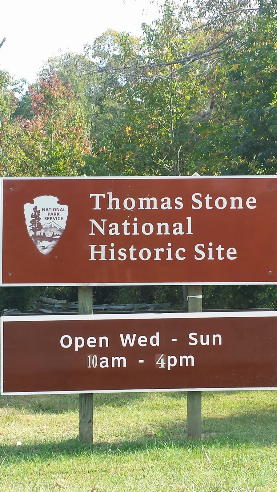
TRAVEL: 3 miles from College Park to Greenbelt Park; 18 miles from Greenbelt to Oxon Cove Park/Oxon Hill Farm; 8 miles from Oxon to Fort Washington National Park; 6 miles from Fort Washington to Piscataway Park/National Colonial Farm; 17 miles from Piscataway to Thomas Stone NHS; 45 mile return trip to College Park.

This
is available for camping - RV sites are asphalt – however there are no
Electric or Water hookups. Cost is $16/night
or $8 for seniors. I’m staying where
I’m at.
Greenbelt provides
overnight camping, as well as, plenty of picnic areas and trails. An urban oasis, just 12 miles from downtown
DC. The NPS established the Park in
1950. The Baltimore-Washington Parkway
was opened in 1954 to create an uninterrupted scenic route for passenger
vehicles between the two cities.
There are 4 trails
in the park ranging from a mile to 5.3 miles in length.
Most likely a
destination for a drive when the leaves turn – plenty close for scouting
activities – there is a separate area set aside for scouts..

OXON COVE PARK/OXON HILL FARM – Oxon Hill, MD
This
has been a National Park site since 1967.
Most of the buildings are original farm structures. Some authentic period structures have been
added. It’s a working farm that caters
mostly to school groups. It represents a
time when horsepower came directly from the horses. I can see where children will delight from
the farm animals.
 |
| Oxen Hill Farm |
The
oldest structure in the park is the
Debutts Family home and was known as Mount Welby. The family owned the property from 1805 until
1843. Over this period of time the
family witnessed The Battle of Bladensburg (War of 1812) and the burning of
Washington. Originally, set up as a
tobacco farm the family had slaves.
Later they grew wheat and most likely sold their slaves south.
100 FORT WASHINGTON NP – Fort Washington, MD

Fort Washington has a history of changing military strategy and technology. It reflects the debate of how best to defend the US from 1808 through 1922.
Fort Washington lies on the Maryland shore of the Potomac River south of Washington, DC.
.jpg) |
| Fort Washington |
The original fort was designed by LTC Walker K. Armistead (brother of MAJ George Armistead who defended Fort McHenry). It was designed to defend against wooden ships. Later – during/after the Civil War, it was upgraded to defend against armored ships with 15” Rodman Guns (as was Fort McHenry). By the late 19th century it was outfitted with Endicott-era guns: 10” guns on disappearing carriages, 12 inch mortar batteries and 4” rifles. This fort was part of the Coastal Artillery, like that at Sandy Hook, N

In
1912 the post was no longer needed, it became HQ for the 12th
Infantry. During WW II the AG Officer
Candidate School was based here. Deactivated in 1946 and transferred to the NPS
so the historic fabric of the fort could be preserved.
101 PISCATAWAY PARK/NATIONAL COLONIAL FARM – MD
Piscataway is where
the land meets water, Piscataway Park is green space and the National Colonial
Farm is where the park brings the past to life.
 |
| Tobacco Barn |

The Foundation has
a small Visitor Center/Gift Shop. A NPS
partner, there are no Rangers on site.
There wasn’t much
going on when I visited. The woman made
sure that I knew this was Accokeek not NPS – although Piscataway runs several
miles along the Potomac River. Fort Washington
is the HQ address for Piscataway Park.
This location had been administered by the NPS since 1997. The Stone family owned this property from 1770 – 1936.
Thomas Stone
started building his country home Haberdeventure (dwelling place of the winds)
in the 1770’s as a place to raise his family.
This was a plantation, Stone owned slaves. In 1776, he signed the Declaration of
Independence and wrote himself into history.
 |
| Thomas Stone House |
As a signer of the Declaration, he would have been hunted down and hanged as a traitor to the British Crown if the colonists had not won Independence. His primary residence was in Annapolis. Stone died in 1787. The property was passed down through five generations of Stones until it was sold in 1936. Eventually, given to the NPS.
 |
| Thomas Stone - Harpsichord in corner |
THURSDAY – October 2, 2014
WEATHER: low of 55 in the
morning, cloudy to partly sunny to cloudy to mostly sunny high in the 70’s
TRAVEL: drove about 47 miles to Hampton NHS near Baltimore – then to COLLEGE PARK/U MARYLAND station and caught the METRO to SHAW/HOWARD U station – walked to Carter G. Woodson NHS, African American Civil War Memorial, the African American Civil War Museum and Mary McLeod Bethune Council House NHS. Caught the Green Line at U STREET station and back to COLLEGE PARK/U MARYLAND. It cost $5.10 to park at COLLEGE PARK/U MARYLAND. METRO fares were $2 or less each way.

103 HAMPTON NHS – Towson, Maryland
Construction
started in 1783 and was completed in 1790 by Capt Charles Ridgely. This was a mansion and perhaps the largest
residence in the US for a long time. By
family custom, the Hampton estate belonged to eldest son in each
generation. Capt Ridgely did not have
any children, so his nephew changed his name to Charles Ridgely Carnan in order
to inherit the estate. These people had
money. The estate passed through 7
generations – one a Maryland Governor; another a Southern sympathizer - of
Ridgely’s ,until sold to the Mellon family trust , which donated it to the federal
government in 1948. The NPS took over
administration of the mansion and its 60 acres in 1979.

Built in Georgian style it reminded me of Martin Van Buren’s house near Kinderhook, NY, but I think this is much larger.
 |
| Hampton |
In
the 1820’s, the estate grew to 25,000 acres to include an iron works and 300
slaves. Originally a tobacco plantation,
it transformed to grains after the soil was ‘used up.’ The mansion took 7 years to build and 3 years
for the NPS to refurbish. There are over
35 rooms on 3 floors. The 3rd
floor is not open to the public but the main rooms on the 1st and 2nd
floors are refurbished in period style to represent each of the seven
generations. NPS spent over $3 million between to “get it right.” I’m glad I stopped here; the one hour house
tour was done well by very knowledgeable volunteer. You can spend at least another hour or more
walking the grounds. There is no charge
– there is also a Farm Tour scheduled.
 |
| Carter G Woodson Home |
104 CARTER G WOODSON NHS – Washington, DC
This site is under renovation. Dr. Carter G.
Woodson (1875-1950) is considered the ‘father of black history.’ He early education was self taught. At age 20 he graduated from High School at
the age of 22; a Bachelor’s degree form Berea College in KY, a Masters from the
University of Chicago in 1908 and a
Harvard PhD in 1912. He was the second
African American, after W.E. DuBois, to
receive a doctorate. Woodson lived here
from 1915 until his death in 1950.
In 1915, Woodson and Jesse E. Moorland co-founded the
Association for the Study of Negro Life and History (ASNLH). The organization
was the platform that launched Woodson's mission to raise awareness and
recognize the importance of Black history. He believed that publishing
scientific history about the black race would produce facts that would prove to
the world that Africa and its people had played a crucial role in the
development of civilization. He
pioneered “Negro History Week,” between Washington and Lincoln’s birthdays,
in 1926.
.jpg) |
| African American Civil War Memorial |
This
memorial is located immediately outside the entrance to the U
STREET/AFRICAN
AMERICAN station of the METRO’s Green Line. George W. Bush signed
legislation authorizing creation of memorial in 1992.
This
is the only national memorial to honor
the contribution of the 166 Regiments compromising the US Colored Troops (USCT)
and sailors during the Civil War.
Inscribed on the
Wall
of Honor are the names of more than 200,000 African American soldiers, 7,000 white officers and 2, 145
Hispanic surnames who fought for the Federal Governement during the Civil War.
The
sculpture, designed in bronze by Ed Hamilton, depicts three infantrymen and a
sailor. The back of the statue shows a
somber scene of a soldier leaving home, bidding goodbye to family.
 |
| Entrance African American Civil War Museum |
Despite the
urging of Frederick Douglass and others, President Lincoln would not allow
blacks to fight until it became clear that the Union would not be preserved
without the aid of the black soldier.
The Emancipation Proclamation only gave freedom to all slaves in the
states of rebellion.
On May 22,
1863 the Bureau of US Colored Troops (USCT) was established to recruit, train,
outfit and deploy what would becomes a force of 200,000 African American
soldiers.
This is a
small museum. Although, not part of the
NPS, it is well done and tells the story appropriately.
105 MARY MCLOED
BETHUNE COUNCIL HOUSE NHS – Washington, DC
This
place has a gate in front, I tried the gate – it was open I walked up to opened
it and there was a locked door – I rang the bell and was greeted by a NPS
ranger.
A
ranger gave me a 10 minute brief about Mary McLeod Bethune and a short
background of Charles G Woodson (they were friends and neighbors). A volunteer gave me a tour of the house. I also heard Bethune give her – legacy speech
– recorded at this house in 1955 – an impressive speaker.
 |
| Mary McLoed Bethune Home |
 Mary
McLeod Bethune (1875-1955 )was the 15th of 17 children born in
Mayesville, SC to freed slaves. As an American educator and civil rights leader she is best
known for starting a private school for African-American students in Daytona Beach, Florida. She attracted donations of time and money, and developed
the academic school as a college. It later continued to develop as Bethune-Cookman University. She also was appointed as a national adviser to President Franklin D. Roosevelt. She was known as "The First Lady of The Struggle”
because of her commitment to bettering African Americans.[1]
She was close to the Roosevelt Administration.
She headed the Negro Division of the National Youth Adminstration, which
made her the highest ranking African American woman in government. She also founded the National Council of Negro
Women (NCNW) in 1935. NCNW’s mission was
to unite African American women to combat racial and gender inequality, not
just in the US, but worldwide. The first
national HQ of the NCNW was established at this house on Vermont Ave in 1943.
Mary
McLeod Bethune (1875-1955 )was the 15th of 17 children born in
Mayesville, SC to freed slaves. As an American educator and civil rights leader she is best
known for starting a private school for African-American students in Daytona Beach, Florida. She attracted donations of time and money, and developed
the academic school as a college. It later continued to develop as Bethune-Cookman University. She also was appointed as a national adviser to President Franklin D. Roosevelt. She was known as "The First Lady of The Struggle”
because of her commitment to bettering African Americans.[1]
She was close to the Roosevelt Administration.
She headed the Negro Division of the National Youth Adminstration, which
made her the highest ranking African American woman in government. She also founded the National Council of Negro
Women (NCNW) in 1935. NCNW’s mission was
to unite African American women to combat racial and gender inequality, not
just in the US, but worldwide. The first
national HQ of the NCNW was established at this house on Vermont Ave in 1943.  |
| John A Logan |
LOGAN CIRCLE - Named after Congressman -Civil War General and later Illinois Senator John A. Logan. Arguably the most successful of the Union army's political generals, was born in pro-slavery region of Southern Illinois in 1826. His father, a successful doctor and farmer, was also heavily involved in local and state politics, representing Franklin and Jackson counties in the Illinois State assembly for nearly a decade. After a smattering of formal and informal education, John Logan volunteered for service in the Mexican War but was mustered out in 1848 without seeing any action. He attended law school at Louisville University and after a brief stint as a prosecuting attorney, turned to politics, winning his father's seat in the state assembly in 1853.

When his immediate
superior, Maj. Gen.
James B. McPherson was killed in the Battle of Atlanta, Logan temporarily
commanded the Army of the Tennessee but was subsequently replaced by West Point
graduate Maj. Gen. Oliver O. Howard, presumably because William T. Sherman was
skeptical of politicians in uniform. The Illinoisan viewed this as a personal
slight which gave him a very dim view of West Pointers in the future.
Logan also
was owner and developer of the land in this area of Washington. I wouldn’t doubt that he funded his own
statue memorial.
FRIDAY – October 2, 2014
WEATHER: cloudy all
day, low seventies, started to rain about 8:15 pm
TRAVEL: Today was an adventure. I meant to drive to some of the places I visted today – then thought perhaps the train would do – well it did – and it didn’t. Parked at COLLEGE PARK/U MARYLAND and took the Green Line to ANACOSTIA. Walked about ¾ mile to the Frederick Douglass House. From there walked about a mile to National Capitol Parks-East HQ located in Anacostia Park. Walked the Anacostia Parkway trail, after 75 minutes I reached Benning Rd – there was a cab driver golfing on the Parkway – I asked him if he “wanted a fare?” He wasn’t all that enthusiastic – but attempted to take me to Kenilworth Park and Aquatic Gardens – I was beat – he didn’t know where it was - so we called the ranger at the park. We got to the general area (DEANWOOD STATION) asked a bus driver there – he had no idea – checked with a few other folks – no idea – I checked MapQuest and in six blocks we were there. On the return I walked to DEANWOOD caught the Orange Line to SOUTH CAPITOL. Walked some more and got on the Green Line at ARCHIVES station in order to return to COLLEGE PARK/ U MARYLAND. It was a long day.

106 FREDERICK DOUGLASS NHS – Washington, DC
About
a ¾ mile walk from the ANACOSTIA METRO station. It is a small Visitor Center but there is a
very good 17 minute film describing Douglass’s life. There is a parking lot but I’m glad I took public
transportation.
1818 Douglass was in Talbot County,
MD. His mother was a slave, his father
was white.
1826 Douglass was sent to Baltimore as a
house servant. He sees knowledge as a
means
to
freedom. He teaches himself how to read.
1833-34 He was moved to a nearby plantation and deemed
unmanageable. He is hired out to
a slave breaker – and fights back.
1836 Attempts to escape is returned to
Baltimore, learns the trade of a ships
caulker.
1838 Escapes slavery by boarding a train
to New York City disguised as sailor.
 |
| Frederick Douglass |
1845, publishes Narrative
of the Life of Frederick Douglass.
Leaves for Europe to
escape salve catchers who
know his identity. He named his owners
in the book.
1847 English friends buy his freedom and he
returns to the US.
1847-59 Launches the newspaper The North Star in Rochester, NY. Douglass becomes an
outspoken defender of women’s
rights and political action as a means to abolish
slavery. He opposed John Brown’s raid in 1859 but due
to his alliance with Brown
seeks asylum in Canada.
1863 Meets with Lincoln and serves as an
advisor.
1872-81 Moves to Washington, buy a house and break
the “whites only” covenant by
purchasing Cedar Hill; serves
as US Marshall of DC from 1877-1881. His wife Anna dies
in 1882; he remarries in 1884
– to Helen Pitts, a white woman. The
interracial
marriage was opposed by his 5
children.
1895 Dies at Cedar Hill.
 |
| Cedar Hill - Frederick A Douglas House |
His
second wife, Helen, organized the Frederick Douglass Memorial and Historical
Asscociation in 1900. In 1916 it joined
with the National Association of Colored Women’s Clubs. In 1962 the 25 room house with it views of DC
was entrusted to the care of the NPS.
116 NATIONAL
CAPITAL PARKS: EAST – Washington, DC (#116 on spreadsheet)
National Capital Parks-East is
responsible for a number of park sites, parkways and statuary covering more
than 8,000 acres of historic, cultural, and recreational parklands from Capitol
Hill to the nearby Maryland suburbs.
These include:
Anacostia Park Fort Washington Park *Fort Dupont Park
Frederick Douglass NHS Greenbelt Park Kenilworth Aquatic Gardens
Mary McLeod Bethune NHS Oxen
Cove Park Oxon Run Parkway
Carter G. Woodson NHS *Fort
Foote *Harmony
Hall
*Suitland Parkway Shepherd Parkway Civil
War Defenses of Washington
*Capital Hill Parks Piscataway Park Baltimore-Washington Parkway
*Fort Circle Parks
CIVIL WAR DEFENSES
OF WASHINGTON – Washington, DC
Fortifying the
nation’s capital became the Union’s greatest concern after the defeat at
Manassas, VA in the summer of 1861. MG John G. Barnard accepted the massive
task of building a defense for Washington (for the South Robert E. Lee was chosen to build the defenses of Richmond). Barnard developed a connected system of
fortifications occupying every prominent point around Washington. By the end of the Civil War, the “Father of
the Defenses of Washington” had directed the construction of 68 forts, 93 gun
batteries, 20 miles of rifle pits and 32 miles of military roads around the
capital.
 |
| Civil War Defenses of Washington map |
Most of the
fortifications were dismantled or abandoned by 1866. Decades later, a plan to connect the historic
sites with a scenic automobile route paved the way for their preservation. Many of the forts surrendered to time and
urbanization. Many also remain protected
by the NPS, where parks and woodlands occupy heights where guns once scanned
the horizon.
The design for the Defenses of Washington was based
on a textbook published in 1836 called A TREATISE ON FIELD FORTIFICATIONS, by
Dennis Hart Mahan. Mahan was a professor of civil and military engineering at
West Point.
FORT CIRCLE PARK –
Washington, DC
Fort Mahan was named after Dennis Hart Mahan,
an American soldier and educator. In 1824, he graduated from West Point.
He taught civil and military engineering at the Military Academy and became an
authority on military engineering. His works include Complete Treatise on Field
Fortifications (1836), Summary on the Cause of Permanent Fortifications and of
the Attack and Defense of Permanent Works (1850), and An Elementary Course of
Military Engineering (2 vol., 1866–67).
FORT DUPONT PARK –
Washington, DC
Fort Dupont Park offers over 10 miles of trails
to its visitors. The seven mile long Hiker/Biker Trail connects six Civil War
earthwork fortifications for mountain bikers and hikers to learn about the rich
history of the Civil War Defenses of Washington while exercising in a beautiful
mature forested park.
CAPITAL HILL PARKS
– Washington, DC
The Capitol Hill Parks include several park
areas east of the U.S. Capitol. Included in this group are Folger, Lincoln,
Stanton, and Marion Parks, the Eastern Market and Potomac Avenue Metro
stations, and several smaller land parcels such as Seward Square, Twining
Square, the Maryland Avenue Triangles, the Pennsylvania Avenue Medians, and 59
inner-city triangles and squares
SUITLAND PARKWAY –
Washington, DC

The
park covers 1,200 acres stretching the length of the Anacostia River from the
Frederick Douglass Memorial Bridge north to the DC/Maryland line. It is a multi-use recreational park, with
shoreline access, swimming pool, skate park, trails, and picnic areas.
Beginning
in 1914, the Army Corps of Engineers built a seawall along the banks of the
Anacostia River, dredged the river and used the sediment to fill wetlands. Park construction and landscaping continued
through the 1920s and 1930s. In 1933 management of the park was turned over to
the NPS.
ANACOSTIA RIVERWALK TRAIL – At Capitol Parks East Headquarters I was told it
was about a 3 miles walk along this trail/parkway to reach Kenilworth. The trail generally follows the Anacostia River and passes through both
developed and undeveloped areas. The
trails design includes a 10-12 foot wide asphalt and concrete path and bridges. I walked on this trail for about 1 ½ hours
from Capital
Parks East Headquarters to trail as far as Benning Road. I was trying to get to Kenilworth Park, after the 1 ½ hours I called Kenilworth
and found that the trail was not yet, finished and was another 4 miles
away. The trail will eventually be 20
miles long and link 16 waterfront neighborhoods along the Anacostia River.

KENILWORTH PARK
& AQUATIC GARDENS – Washington, DC
Difficult
to locate, Kenilworth is probably worth visiting when the flowers are in
bloom. People who live and work within 4
blocks of this location have never heard of the place.
Kenilworth
is the only NPS unit dedicated to cultivating water-loving plants. The park has 45 ponds filled with a variety
of tropical and hardy water lilies, lotus, and other aquatic plants. This is a water garden.
Water
lilies are hardy plants that begin blooming in late May. Tropical water lilies are more open flowers
with bright colors, rippled and spotted leaves.
They bloom in late July through early fall. The lotus usually bloom late June through
mid-August and have large leaves growing several feet above the water.

BACKGROUND: After service in the Civil War, Walter B.
Shaw working as a clerk for the Treasury Department bought 30 acres from his
in-laws in the 1880s. He planted water
lilies in a pond as a hobby. The hobby
became a collection and sold blooms around the world.
 |
| Kenilworth Gardens - dead lotus pulled from the gardens |
 |
| James A Garfield |
JAMES A GARFIELD MONUMENT
This monument is located on the grounds
of the United States Capitol in the circle at First Street, S.W., and Maryland
Avenue.
ULYSSES S. GRANT
MEMORIAL – Washington, DC
The bronze and marble Ulysses S. Grant Memorial by Henry
Merwin Shrady is located by the reflecting pool at the east end of the National
Mall, west of the United States Capitol. Its central figure depicts the Civil
War general (and future president) seated and still on horseback, as was his
custom while observing a battle; bronze reliefs on the marble pedestal show
infantry soldiers on the march. Four bronze lions around the pedestal impart a
sense of strength and dignity. At the ends of the monument, groups of soldiers
and horses appear in tumultuous action, with cavalry at the north and artillery
at the south. Measuring 44 feet high and occupying a marble platform over 250
feet long and 70 feet deep, the monument is the largest statuary group in
Washington, D.C.; the sculpture of Grant is among the largest equestrian statues in the world.
The Congress authorized the creation of the memorial in 1901. In late 2011, the care of the monument was transferred from the National Park Service to the Architect of the Capitol.
The Congress authorized the creation of the memorial in 1901. In late 2011, the care of the monument was transferred from the National Park Service to the Architect of the Capitol.
The AOC
is responsible to the United States Congress and the Supreme Court for the
maintenance, operation, development and preservation of 17.4 million
square feet of buildings and more than 553 acres of land throughout Capitol
Hill. The AOC also provides professional expertise on the preservation of architectural
and artistic elements entrusted to its care, and provides recommendations
concerning design, construction and maintenance of the facilities and grounds.
 |
| Peace Monument |
The Peace
Monument, also known as the Naval
Monument or Civil War Sailors Monument, stands
on the grounds of the United States Capitol in Peace Circle at First Street, N.W., and Pennsylvania Avenue, Washington, D.C. The 44 foot (13.4 m) high white marble memorial was erected from 1877-1878 to commemorate
the naval deaths at sea during the American Civil War. Today it stands as part of a three-part sculptural group
including the James A. Garfield Monument and the Ulysses S. Grant Memorial.
 |
| George Gordon Meade |
GEORGE GORDON MEADE MEMORIAL – Washington, DC
This monument is
located on the corner of Pennsylvania Avenue and 4th Street NW. The cylinder shaped statue features a figure of General George Meade on the proper front and a figure of War on the
proper back, surrounded by six figures standing side by side. The six figures,
all allegorical representations of Loyalty, Chivalry,
Fame, Progress, Military Courage and Energy, were used by the artist to show
what he believed are traits needed to make a "great general.
 |
| Winfield Scott Hancock |
Located on Pennsylvania Avenue, across the street
from the National Archives. Winfield Scott Hancock (1824 – 1886) was a
career U.S. Army officer and the Democratic nominee for President of the United
States in 1880. He served with distinction in the Army for four decades,
including service in the Mexican-American War and as a Union general in the
American Civil War. Known to his Army colleagues as "Hancock the
Superb," he was noted in particular for his personal leadership at the
Battle of Gettysburg in 1863. One military historian wrote, "No other
Union general at Gettysburg dominated men by the sheer force of their presence
more completely than Hancock."
 |
| Navy Memorial |
The United States Navy Memorial, on Pennsylvania Avenue NW between 7th Street Northwest and 9th Street Northwest. The Naval Heritage Center is located in the heart of the Penn Quarter and offers visitors the chance to learn about the history and heritage of the men and women of the United States Navy – past, present and future.. there is a Visitor Center/Museum here that I did not visit.
SATURDAY – October 4, 2014
WEATHER: 66 degrees
at 5:30 am – cloudy – mostly sunny by 11:30 in the low 70s – a good day
TRAVEL: 20 miles to Glen Echo, MD (Clara Barton/Glen Echo Park), another 10 miles to Great Falls Park and then 8 more to Claude Moore Farm. A return trip of 22 miles.

 |
| Clara Barton House |
It was built in the style of a “Johnstown Home” – a style built by the Red Cross to provide temporary housing for victims of the May 31, 1889 Johnstown Flood. Sunlight shines through
Stained-glass red crosses in the front windows. Living quarters were available for Red Cross staff or volunteers returning from disaster sites. The house has 26 rooms. It served a housing, warehouse, and headquarters for the Red Cross.
 |
| Clara Barton house - 2nd & 3rd floors |
Clara Barton
 |
| Clara Barton House bandages used for wallpaer |
1825-50 Starts school at age 3, teaching at
age 17
1850 Attends
Clinton Liberal Institute in New York to further her education
1852 Establishes the first free public
school in New Jersey, in Bordertown, NJ
1861-65 Aids Civil War wounded at 2nd
Manassas, Antietam, Fredericksburg, Wilderness, Spotsylvania
1870-71 Works with the International Red Cross in Europe
1870 Franco-Prussian War – relief
work
1881 Established & heads the American Red Cross. Serves 23 years as President
1884 Michigan – forest fire relief
work
1889 Johnstown, PA – flood relief
work
1891 Initial construction of house,
serves as warehouse
1892 Russia – famine relief work
1896 Armenia - relief work
1897 Moves to Glen Echo, remodels and
back rooms serve as headquarters
1898 Works in Cuba – Spanish American
War
1900 Galveston, TX – hurricane relief
work
1904 Resigns as Red Cross president.
1905 Establishes National First Aid
Association of America
1912 Dies at Glen Echo, MD
 |
| Glen Echo Park Carousel |
 |
| Glen Echo Park map |
The
only amusement park managed by the NPS.
This palce reminded me of Muskego Beach complete with Ballroom, Penny
Arcade, Dodge-em cars, and a carousel.
The
popularity of urban Amusement Park declined in the 1960s (State Fair Park and
Muskego Beach). Glen Echo Park and its
centerpiece carousel, was rescued by a group of local citizens in 1968. To prevent further development of the area
along the scenic Potomac River Palisades the federal government acquired the
site in April, 1970 and later placed it under the care of the NPS.
Today,
the Park not only maintains the old amusement park design but the buildings
serve as home to the Glen Echo Park Partnership for Arts and Culture. When I visited, there were artist workshops
in sculpture and painting. The Park is
adjacent to the Clara Barton NHS.
 |
| Great Falls Park |
 |
| Great Falls Park - Overlook 2 |
Today there are 6 trails in the Park ranging form 1.8 – 3.0 miles in length. The weather today was perfect – sunny and in the low 70s – parking lots were all but full. There is a $5 per car fee to enter the park.
CLAUDE MOORE COLONIAL FARM – McLean, VA
 The
Claude Moore Colonial Farm at Turkey Run is a living history museum that
portrays family life on a small, low-income farm in 1771, just prior to the
Revolutionary War. It is a privately operated National Park. No rangers here and a $3 entrance fee.
The
Claude Moore Colonial Farm at Turkey Run is a living history museum that
portrays family life on a small, low-income farm in 1771, just prior to the
Revolutionary War. It is a privately operated National Park. No rangers here and a $3 entrance fee. |
| Claude Moore Farm Girls on farm by Geese |
The
Farm has achieved national recognition for its innovative educational
programming that uses the 18th-century Farm as an authentic representation of
colonial agricultural history to provide perspective and context for present
day life. Each year, thousands of students visit this working class farm, which
recreates the life and times of a family living in northern Virginia in 1771.
SUNDAY – October 5, 2014
WEATHER: temp was 39 at 4:30 am
sky clear, 46 in the trailer, high of 62 ftoday.with sun – it was another
pleasant day.
TRAVEL: drove today – less traffic – glad I had a GARMIN and ON-STAR. Some of these places do not have addresses. It took ON STAR advisors 3 trys to get me to the LBJ Memorial. They never were successful – the last one got me closest – but I found the parking lot myself.. It’s across fro the Pentagon on an island.
 |
| St. Joseph's |
On February 22, 1931, Jesus appeared to this simple nun, bringing with Him a wonderful message of Mercy for all mankind. Of course the priest told a much more captivating story. Saint Faustina. She was canonized by John Paul II.
IWO JIMA MARINE CORPS MEMORIAL
The Marine Corps War Memorial is a United
States military monument outside the walls of Arlington National Cemetery and
next to the Netherlands Carillon, in Arlington Ridge Park, Arlington, Virginia.
"In
honor and in memory of the men of the United States Marine Corps who have given
their lives to their country since November 10, 1775."
.jpg) |
| USMC Memorial |
The United States Marine Corps War Memorial represents this nation's gratitude to Marines and those who have fought beside them. While the statue depicts one of the most famous incidents of World War II, the memorial is dedicated to all Marines who have given their lives in the defense of the United States since 1775.
On the morning of February 19, 1945, the 4th
and 5th Marine Divisions invaded Iwo Jima after an ineffective 72-hour
bombardment. The 28th Regiment of the 5th Division, was ordered to capture
Mount Suribachi. They reached the base of the mountain on the afternoon of
February 21 and, by nightfall the next day, had almost completely surrounded
it. On the morning of February 23, Marines of Company E, 2nd Battalion, started
the tortuous climb up the rough terrain to the top. At about 10:30 am men all
over the island were thrilled by the sight of a small American flag flying from
atop Mount Suribachi. That afternoon, when the slopes were clear of enemy
resistance, a second, larger flag was raised by five Marines and a Navy
hospital corpsman: Sgt. Michael Strank, Cpl. Harlon H. Block, Pfc. Franklin R.
Sousley, Pfc. Rene A. Gagnon, Pfc. Ira Hayes, and PhM. 2/c John H. Bradley,
USN.

Arlington National Cemetery is comprised of land that once belonged to
George Washington Parke Custis, grandson of Martha Washington and adopted
son of George Washington. Custis spent his life commemorating Washington and
built Arlington House on the 1,100-acre plantation as a memorial to the first president. In 1857, Custis willed the property to his only surviving daughter Mary Anna Randolph Custis, who was married to Robert E. Lee.
 |
| Arlington Changing of the Guard Tomb of the Unknown Soldiers |
 |
| Kennedy Gravesites below Arlington House |
IN HISTORY OCTOBER: On October 12, 2000, the U.S. Navy destroyer,
the USS Cole docked for refueling at the port of Aden in Yemen. At
approximately 11:18 a.m. local time, a small craft approached the port side of
the ship and set off an explosion. The terrorist organization al-Qaeda took
responsibility for the attack. The blast put a 40-by-40 foot gash in the port
side of the destroyer, taking the lives of 17 sailors and injuring 39 others.
Electronics Technician Chief Petty Officer Richard D. Costelow, Signalman
Seaman Cherone L. Gunn, and Hull Maintenance Technician Petty Officer 2nd Class
Class Kenneth E. Clodfelter, three of the 17 victims, were laid to rest
side-by-side in Section 60 of Arlington National Cemetery.
 |
| Arlington House |
108 ARLINGTON HOUSE, ROBERT E. LEE MEMORIAL – Arlington, VA
Arlington House, The Robert E. Lee
Memorial, formerly named the Custis-Lee Mansion, is a Greek revival style
mansion located in Arlington, Virginia, USA that was once the home of
Confederate General Robert E. Lee.
Built by George Washington Parke Custis and his slaves
between 1802 and 1818, the house and grounds have served many purposes over the
last two hundred years: a family home for the Lees and Custises, a plantation
estate and home to 63 slaves, a monument honoring George Washington, a military
headquarters, a community for emancipated slaves and a national cemetery.
Robert E. Lee made no attempt to visit or restore his
title to Arlington before his death in 1870. Mary Lee died in 1873, having
visited to the house only once, a few months before her death.
In April 1874, Robert E. Lee's eldest son, George Washington Custis Lee, filed suit against the United States government in a Virginia circuit court to
regain his property.[ A
jury found in favor of Lee, leading to extensive appeals by both parties. In
1882, the Supreme Court of the United States ruled in favor of Lee in United States v. Lee, 106 U. S. 196. The
court, by a 5-4 majority, found that the estate had been "illegally
confiscated" in 1864 and ordered it returned. But Lee was less interested in obtaining the
estate than he was in just compensation for it. After several months of
difficult negotiations, Lee and the federal government settled on a sale price
of $150,000 ($3,796,607 in 2014 dollars). Congress enacted legislation funding
the purchase on March 3, 1883; Lee signed over the title on March 31; and the
title transfer was recorded on May 14, 1883.
109 THEODORE ROOSEVELT ISLAND
 |
| Map Theodore Roosevelt Island |
 |
| Theodore Roosevelt |
In the 1930s landscape architects transformed Mason’s Island from neglected, overgrown farmland into Theodore Roosevelt Island, a memorial to America’s 26th president. They conceived a “real forest” designed to mimic the natural forest that once covered the island. Today miles of trails through wooded uplands and swampy bottomlands honor the legacy of a great outdoorsman and conservationist.
110 GEORGE WASHINGTON MEMORIAL PARKWAY – Washington, DC
This
includes the following units:
USMC
War Memorial Arlington House, the Robert E. Lee Memorial
Netherlands
Carillion Lady
Bird Johnson Park
Theodore Roosevelt
Memorial Lyndon
Baines Johnson Memorial
 |
| Map George Washington Memorial Parkway |
 |
| LBJ Memrorial |
111 LYNDON BAINES JOHNSON MEMORIAL GROVE
President Johnson came here often when
he needed to escape from the stresses of building a Great Society. After he
died, his wife chose this place for his memorial. A landscape of serpentine
paths, white pines, a granite monolith, and an open meadow honors his legacy of
social justice and conservation legislation.
 |
| Map Rock Creek Park |
Rock Creek Park is a large natural area with public park facilities that bisects the northwestern urban areas of Washington, D.C. The park is administered by the National Park Service. An urban oasis with hiking trails, tennis, golf, planetarium, nature centre, horseback riding stable, ,plus ranger-led wildlife programs & an amphitheater.
ROCK
CREEK PARKWAY
The Rock Creek and Potomac Parkway, often
known simply as the Rock Creek Parkway, is a parkway maintained by the National
Park Service as part of Rock Creek Park.
MONDAY – October 6, 2014
WEATHER: 43 degrees
at 4:30 am; 49 in the trailer a 2 dog night.
TRAVEL: drove to College Park/U of Maryland station; used the METRO rail and bus system, and foot travel.

 |
| Rotunda Ceilling |
9
am tour arranged through Congressman Paul Ryan’s office. Nothing special here – it just meant that I
had a reserved ticket waiting for me.
Same tour as anyone would get. In
fact, I think it’s the same tour I got when I visited Washington in 1964 –
except the security now is much tighter – and there is a new visitor center that
handles thousands of people as cattle.
Still a wonder to visit - a 45 minute tour. Unfortunately, my guide – in a group of about
40 – was not at the top of the list for enthusiasm or interest. Just herded us through and said what needed
to be said – no more. I had a $2.50
coffee in the cafeteria. Congress was
not in session so there was no reason to visit the galleries.
 |
| Senator Robert A Taft |
ROBERT
A. TAFT MONUMENT – Washington, DC
The Robert
A. Taft Memorial and Carillon is dedicated as a memorial to U.S. Senator Robert Alphonso Taft, son of President William Howard Taft.
The memorial is located north of the Capitol, on Constitution Avenue between New Jersey Avenue and First Street, N.W. Designed
by architect Douglas W. Orr, the memorial consists of a Tennessee marble and a 10-foot (3.0 m) bronze statue of Senator Taft sculpted by Wheeler Williams. The shaft of the tower measures 100 feet (30 m) high, 11
feet (3.4 m) deep, and 32 feet (9.8 m) wide. Above the statue is
inscribed, "This Memorial to Robert A. Taft, presented by the people to
the Congress of the United States, stands as a tribute to the honesty,
indomitable courage, and high principles of free government symbolized by his
life."
 |
| Japaness American WW II Patriotism Memorial |
 |
| Japaness American WW II Patriotism Memorial |
Rising above the rest of the memorial the cranes are
visible from beyond the memorial walls, which celebrates the ability to rise
beyond limitations. Their postures reflect one another - one wing pointing
upwards, the other downwards, mirroring each other and representing the duality of the universe. Pressing their bodies against one another
and seeming to hold onto the barbed wire, the birds show individual effort to
escape restraint with the need for communal support and interdependence on one
another.[4]
According to the National Japanese American Memorial
Foundation, the memorial:
.jpg) |
| Japaness American - WW II Patriotism Memorial |
 |
| National Guard Museum 9-11 |
 |
| National Guard Museum One Massachusetts Avenue |
 |
| National Guard Museum |
Once you get in, past the guard –
by using the intercom to enter – the museum tells the story of the National
Guard’s history from the militia era to the 21st century. There is no charge – been here before – not
much changed – allow 20-30 minutes. The
highlight is the flag of the Civil War’s 2nd Wisconsin Infantry
National Colors hung in the entry hall.
 |
| National Guard Museum 2nd Wisconsin Volunteer Infantry Regiment on left - Iron Brigade of the Civil War |
 |
| National Guard Museum Multiple Launch Rocket System - Gulf War |

Lunch at the Dubliner. Across the street from NGAUS.
Good corned beef and Harp. I’d go there
again.
 |
| Old Post Office Tower |
Pennsylvania Avenue National Historic Site is a National Historic Site in the city of
Washington, D.C. Established on September 30, 1965, the site is roughly bounded
by Constitution Avenue, 15th Street NW, F Street NW, and 3rd Street NW.
A street unlike any other. It is
known the world over as the heart of the Nation's Capital. America's history
has marched, paraded, promenaded, and protested its way along the Avenue.

 I
visited here when the NGAUS Conference was in DC. This place is huge – but only the 6th
largest Cathedral in the world. St.
Peter’s in Rome and St. Patrick’s in NYC are larger. I took the 60 minute tour. Cost me $6.00.
I
visited here when the NGAUS Conference was in DC. This place is huge – but only the 6th
largest Cathedral in the world. St.
Peter’s in Rome and St. Patrick’s in NYC are larger. I took the 60 minute tour. Cost me $6.00.
The
Cathedral is officially the Cathedral Church of St. Peter and St. Paul. It had its beginning in 1893 when Congress incorporated
the Protestant Episcopal Cathedral Foundation.
Built of Indiana limestone, the foundation stone (granite) was laid in
1907 in the presence of Theodore Roosevelt.
The Cathedral was completed in 1990 – 83 years later -when “the final
finial” was placed and witnessed by George H.W. Bush.

Gothic architecture, complete with gargoyles and flying buttresses. It serves as the spiritual home of the nation. However, it has never been funded by the government.
It
was damaged by the August 23, 2011 earthquake.
It is safe but the repair and cleaning will renovation will take 10 years.
This
place is huge – you can visit on a self-guided tour.
TUESDAY – October 7, 2014
WEATHER: low of 63
during the night, it did rain- mostly cloudy – some drizzle -high of low 70s;
rain on and off starting around 7pm.
TRAVEL: METRO Rail and by foot
114 PRESIDENTS PARK
– THE WHITE HOUSE – Washington, DC
With all the recent
breeches in security the security outside the White House is very evident.
The picture below was last week Tuesday September 30th. There was a demonstration in Lafayette
Park (where I'm standing). From the picture you can see that
the public can’t even get near fence.
 |
| White House from Lafayette Park |
I visited the
interior today, compliments of Congressman Paul Ryan. Nothing special the Secret Service needs your
name and checks you out before you are given a GO to visit. Security checks your ID at two separate
locations against a roster they have for approved visitors. There are another two additional screening
facilities before entry. Even so, it
seems more friendly here than at the Capital.
 |
| Aerial View White House |
Vermeil Room: a collection of vermeil
(gilded silver) serves a variety of functions, once a billard room
China Room: set aside by Edith Wilson for
glass and china sued by presidents
Diplomatic Reception Room: an oval room furnished in the
Federal period, this is where FDR broadcast his fireside chats
East Room: the largest in the White House is used for
receptions, ceremonies and press conferences.
Also used as a private showing room for deceased Presidents. A 1938 Steinway concert grand piano decorated
with folk dancing scenes and eagle supports was a gift of the Steinway Company.
Green Room: once served as Thomas
Jefferson’s dining room is now a parlor, used for receptions.
Blue Room: furnished to represent the
period of James Monroe. The White House
Christmas tree is placed in this room.
Red Room: used for small
receptions. John Adams used this as a
breakfast room. It is decorated as an
American parlor 1810-30.
State Dining Room: can seat 130 guests at round tables for dinners
and luncheons.
The
2nd and 3rd floors are used by the Presidential family
and guests. Tours are available most
mornings. By 2-3 pm the rooms are again
available to the President and his invited guests..
A
new White House Visitor Center is
located down the street from the White
House at 1450 Pennsylvania Avenue.
This can be visited at any time.
 |
| John Paul Jones |
The John
Paul Jones Memorial is a
monument in West
Potomac Park in Washington,
D.C.. The memorial honors John
Paul Jones, the United
States' first naval war hero, father of the United States Navy, the only naval officer
to receive a Congressional Gold Medal during the American Revolutionary War,
and whose famous quote "I have not yet begun to fight!"
was uttered during the Battle of Flamborough Head.
Dedicated on April 17, 1912, the John Paul Jones Memorial was the first monument raised in Potomac
Park. The memorial is located near the National
Mall at the terminus of 17th Street Southwest near Independence Avenue on the northern bank of the Tidal Basin. A nearby
marker contains a biographical sketch of John
Paul Jones, and describes the memorial's history and features.
EAST
POTOMAC PARK – Washington, DC
This airy peninsula just south of the Jefferson Memorial drives
a grassy wedge between the Potomac River and the Washington Channel.
The park draws sports enthusiasts throughout the year. You’ll
find one 18-hole and two 9-hole public golf courses, miniature golfing, and a
seasonal public pool.
The scenic riverfront trail that winds around the park’s
perimeter is popular with walkers, runners, bikers, and skaters. In October, it
fills with competitors in the annual Marine Corps Marathon.
Every spring, the park’s Japanese cherry trees burst into clouds
of pink and white. Hains Point, at the
park’s eastern edge, offers stunning views of the river, Fort McNair, and the
National War College. You can watch planes takeoff and land at Ronald Reagan
Washington National Airport, while children frolic on the sandy playground.
 |
| John Ericsson |
JOHN
ERICSON MONUMENT – Washington, DC
John Ericsson National Memorial, located near the National
Mall at Ohio Drive and Independence Avenue, SW, in Washington, D.C., is
dedicated to the man who revolutionized naval history with his invention of the
screw propeller.
During his lifetime, John Ericsson
revolutionized several facets of technology. The Swedish-born engineer-inventor
is best known for his work during the Civil War when he transformed naval
warfare through his design of the iron-plated USS Monitor. The movements of
Ericsson’s pencil across his drafting board were as crucial to victory as the
movements of Lincoln’s armies across battlefields.
.jpg) |
| Arts of War |
ARTS OF WAR & ARTS OF PEACE SCULPTURES – Arlington Memorial Bridge Washington, DC
On
the eastern ends of the bridge and parkway (behind the Lincoln Memorial) are
two pairs of monumental Neo-classical equestrian sculpture. They are placed on identical pedestals. They are called “Arts of War.” It consists
of “Valor” and “Sacrifice.” In “Valor” on the left, the male equestrian
is accompanied by a female standing forward with a shield. In “Sacrifice” a standing female
symbolizing the earth looks up to the rider Mars.
 |
| Arts of Peace Music & Harvest |
 |
| Fords Theatre |
This
has changed a lot since my visit in the late 90’s. Admission is free, but you need a
ticket. Also a self guided tour. It begins with a good museum in the basement,
then you can walk to the main floor or balcony.
 |
| Fords Theate President's Box |
 |
| Peterson House where Lincoln died across the street from Ford's Theater |
PETERSON HOUSE – Washington, DC
Across the street
from the Ford Theatre; the house where Lincoln died.
WEDNESDAY – October 8, 2014
WEATHER: sunny mid 70's
TRAVEL: about 30 miles to Annapolis less than an hour; 30 miles from Annapolis to Rock Creek - it was 2:15 - ran into traffic took me 2 hours to get there
 |
| USNA Golf Course |
 |
| USNA Golf Course |
ANNAPOLIS GC – Annapolis, MD - shot 55 with 21 putts and 1 lost ball. First 3 holes were a 7, a 7 and a 6 then I figured out that Navy Blue was indeed the blue tees - then I found the white tees. Each green here is elevated with sloping sides - no chance to roll on and plenty of opportunities to roll off. Greens are very fast. This is the Naval Academy's home course. Cost me $42.
117 POTOMAC HERITAGE NATIONAL SCENIC TRAIL - DC, MD, PA, VA
I visited Harpers Ferry in April and noticed that they consider themselves part of the Potomac Heritage Trail. The Potomac Heritage National Scenic Trail goes through 4 states and is supported by federal, state and private agencies..
It is a network of bicycle, hiking, and river trails that link the Potomac and upper Ohio River basins. It explores the contrasting landscapes between Chesapeake Bay and the Alleghney Highlands.
Some of the sites I’ve visited that include the Potomac Heritage NST are below:
29 Apr 14 Harpers Ferry
20 Oct 14 Chesapeake & Ohio Canal NHP
1 Oct 14 Piscataway Park
7 Oct 14 National Capital Parks East
5 Oct 14 Rock Creek Park
4 Oct 14 Great Falls Park
5 Oct 14 George Washington Memorial Parkway
18 Oct 14 Prince William Forest Park
25 Jul 14 Appalachian NST
 |
| Rock Creek Golf Course |
 |
| Rock Creek Golf Course |
ROCK CREEK PARK GC – Washington, DC - shot 45 with 21 putts and a lost ball. This course is in bad shape. It is the worst I've played all year - the rough is weeds, the fairway is a lot of dirt - not sure there were tee boxes - cost only $11.
THURSDAY – October 9, 2014
WEATHER: a nice day high in the 70's low
in the high 50s
TRAVEL: none
PENTAGON – Washington, DC
Did not take 10:00
am tour arranged through Congressman Paul Ryan’s office. Taking a sick day.
Today’s
saving grace was a radio station, somehow affiliated with NPR news, but plays
mainly alternative music, except for today.
From 8 am until 7 pm the station played the complete set of Beatle
Albums (English release) in monaural.
Yes, they were records – a box set – which after you gave any kind of
donation – you could win the set along with a turntable that had a USB
port. Just listening was very
satisfying; brought back some memories.
I’ve spent 10
days visiting NHS,
Memorials, Parks, Monuments and not once set foot in any of the
museums. It has been all consuming - the
museums would take weeks . . . . . i.e.
National Archives, Smithsonian Institution,
National Gallery of Art, National Museum
of Natural History,
National Museum of American
History, US Holocaust Memorial
Museum,
National Air & Space Museum, Hershhorn Museum,
Sackler Gallery, African
Art Museum,
Department of Interior Museum, National Aquarium,
National Postal Museum, American Art Museum.
National
Portrait Gallery, Newseum,
National
Museum of Crime and Punishment . . . . .
FRIDAY – October 10, 2014
WEATHER: cloudy, high of 62, little or no wind, on and
off drizzle
TRAVEL: none
Still resting the back . . . .
. . will try to do Sunday what I wanted to visit today.
Today I
heard a wonderful piece of piano music – Six
Caribbean Pieces by Arthur Benjamin.
It was performed by Martin Jones and Richard McMahon on AVM 3029. I was unable to find the sheet music or recording
on line.
I read a
short book, “Guidebook to African
American History in the American Parks.” There are 54 one page articles on sites run
by the NPS
that have something to do with African Americans. I have
noticed an emphasis by the NPS to cover
Native and African American contributions/connections with the sites I’ve
visited. They cover A to Z, from Adams NHP
to Women’s
Rights NHP. So far I’ve
visited 19 or the 54 African American sites.
SATURDAY - October 11, 2014
WEATHER: rained most
of last night, still raining at 5:30 am - 54 degrees high of 58 should be cold
tonight low 40’s – 60s& sunny tomorrow
TRAVEL: About 29 miles to Mt Vernon, travel took a little over an hour, 3 accidents – church is right down the road another 26 miles to Wolf Trap (Fort McNair is very close to Mt. Vernon I must have travelled around ½ of it to get to Wolf Trap) then back here another 28 miles 45 minutes.
DC Area Driving
Observatons:
1. You
don’t see many Ford or GM products on the road.
Mostly Toyota, Nissan, Honda, and more than a fair share of Subaru and
BMW.
2. Speed limits are discretionary, 55 means 65,
65 means 75
3. Lines on the road are suggestions to keep
traffic flowing. It appears you can pass
on solid yellow means. Additionally, you
can pass at 75 or more on the right in order to get to the farthest left lane. Weaving in and out of traffic is common. Uncommon is driving against traffic, but I
saw a jeep come down an entrance ramp and then decide to turn around and go
back.
4. Patience is a virtue.
 |
| Mount Vernon |
MOUNT VERNON NHS– Mount Vernon, VA Mount Vernon is not managed or supported by the federal government. I’ve been here twice before but was not impressed – but ‘what the heck!’ I paid the $17.
 |
| Mount Vernon |
Like most,
no pictures allowed inside the house.
The tour is a constant flow through the mansion with docents placed in
various rooms and halls explaining what’s what.
They switch every 15 minutes – probably to keep them from becoming bored
and worn out.
 |
| Mount Vernon |
There is
a new orientation center, a museum and education
center. You start out with a short
introductory film in the orientation center. There are 2 additional state of
the art films Edcuation Center. One even
has snow Trenton Christmas snow falling from the ceiling and the vibration of
the cannon through your seat.
The two
gardens can take 20 minutes each to enjoy.
These are the best I’ve seen at any
historic sites. There are plenty
of outbuildings, tombs of Martha and George, a pioneer farm, and a slave
memorial (there were over 300 slaves on the plantation). I didn’t even get to the grist mill or
distillery. The original plantation was
huge.
There are a
hotel, restaurant and shops at the entrance.
Tastefully set . . . they
fit. Mount Vernon is a day trip – not a
2 hour visit.
 |
| Good Shpeherd Church Alexandria, VA |
.jpg) |
| Good Shpeherd Church Alexandria, VA |
118
WOLF TRAP NATIONAL CENTER FOR THE PERFORMING ARTS – Vienna, VA
Newmyer Flyer
Tribute to The Everly Brothers – Section Primary Orchestra; Row E Seat 102. I was lucky to get this ticket last week –
ordered on line. This concert is SOLD
OUT. Cost $27 plus $5 handling fee –
very reasonable.
 |
| Wolf Trap |
 |
| Wolf Trap - The Barns |
Newmyer Flyer is/are the producer(s) of the
show. There were two whole bands and 23
total singer/musicians (some apparently doubled as stage hands)- and not all
played at the same time. The Everly Brothers harmonies are unmistakable. There were at least 4 or 5 pairs (sometimes trios)
who sang a good portion of the Everly’s
songs. There were two one hour plus
sets.
Some of the
groupings were better at harmony than others – many
 |
| Wolf Trap - The Barns |
A good show. They were all local - the musicians were very
good – even if the singing wasn’t always right on target. Bottom was played mostly, by two guys on a
stand up bass. There were at least 2 1960 vintage Telecaster’s
and would you believe . . . also 2 Gibson
Model LG1 guitars – they looked worn. I
spoke to one guitar player and only the body of the Telecaster was still
original and it’s been refinished at least 3 times.
The producer plans
a tribute to Traffic in the spring –
that would be interesting.
SUNDAY - October 12, 2014
WEATHER: 48 at 5:15;
53 in the trailer; mostly sunny, high in the low 60’s
TRAVEL: A lot of windshield time. A little more than an hour to College Park to First State NM; another 1 1/2 hours to Assateague Island NS (passed Dover AFB on the way); another 50 minutes to Harriet Tubman NM; 1 ¾ hours back to College Park. A long day. First State and Harriet Tubman were just added stops. They are really new. I had originally, planned to ‘dry camp’ at Assateague – maybe should have – could have spent 2 days there – with the right weather.
.
119 FIRST STATE NATIONAL MONUMENT – New Castle, DE

 |
| Of course it was closed & I wasn't going to wait 4 hours |
From the NPS website: "A New National Park First State National Monument is a new national park which consists of
four areas partners. The National Park Service will soon begin a public process
to develop a management plan for the park. At present, there are no
NPS facilities and limited staff. The
Woodlawn Tract, near Wilmington: New
Castle Court House Museum, New Castle,
Famous as the First State to ratify the Constitution, Delaware was born out of a
conflict among three world powers for dominance of the Delaware Valley.
From this beginning, the region developed a distinct character that tolerated
diversity in religion and national origin and valued independence.
I also visited here in October of 2019. On a Monday. NPS Website said it would be open. Not. BOTTOM LINE: 2 visits and still no passport stamp.
120 ASSATEAGUE ISLAND NATIONAL SEASHORE - Berlin, MD
.jpg) |
| Assateague Island |
 |
| Assateague bay side |
A seashore famous for its wild horse
herds. Plenty of bike and hiking
trails. All is very flat. Probably very buggy in the summer. The visitor center is informative – plenty of
hands on for children. Campsites have no
hookups – pit toilets. My day visit – weather
was perfect.
 |
| Ponies graze in the campground |
This is another barrier island. The dunes are always in motion. The ocean and storms change the island
constantly. Over the Sand Vehicles (OSVs)
are allowed with permit. Pleasant.
 |
| Assateague Island |
 |
| Assateague Island |
121 HARRIET TUBMAN NATIONAL MONUMENT - Cambridge, MD
From the NPS Web Site:
Harriet Tubman Underground Railroad National
Monument is a new national park area. It has no planned park facilities and
will have limited services. It is a park in progress and in the coming years,
you will see services added to the park done in cooperation with Maryland's
planned Harriet Tubman Underground Railroad State Park which is expected to
open in 2015.
I guess I was here a year too early:
I guess I was here a year too early:
The Visitor Experience: A Different Kind of 19th- Century Battlefield
Underground Railroad activity represents a different kind of 19th-century battlefield. Like a battlefield, the events that took place on this ground and the people who participated in them are long gone. Like a battlefield, the fight was for freedom and the risks were life and death. And, like the secret network that the national monument commemorates, the history here may not be immediately obvious.
Underground Railroad activity represents a different kind of 19th-century battlefield. Like a battlefield, the events that took place on this ground and the people who participated in them are long gone. Like a battlefield, the fight was for freedom and the risks were life and death. And, like the secret network that the national monument commemorates, the history here may not be immediately obvious.
You won't see Harriet Tubman represented here
in structures and statues, rather, she is memorialized in the land, water, and
sky of the Eastern Shore where she was born and where she returned again and
again to free others. Tubman would easily recognize this place. The landscapes
and waterways that she navigated and used for sanctuary on her Underground
Railroad missions have changed little from her time.
Harriet
Tubman Underground Railroad National Monument is a new park. In the coming
years, you will see services added to the park done in cooperation with
Maryland's planned Harriet Tubman Underground Railroad State Park. Today, you
can explore Underground Railroad history and Harriet Tubman's story by enjoying
the programs, facilities, and events sponsored and operated by our partners.
This
site is so new – it doesn’t exist yet. The Visitor Center is under construction.
 |
| Harriet Tubman Underground Railroad National Monument to be under construction - someday |
 |
| Blackwater Wildlife Refuge Visitor Center |
 |
| Blackwater National Wildlife Refuge |
The tour route has interpretive markers, audio stops, exhibits and structures. There are 39 stops on the route. There is a smart phone app. “Harriet Tubman Byway” in iTunes or go to http://tubman.toursphere.com on your phone. I did not travel the route; it covers the length of Maryland.
 The
Underground Railroad was a secret
network of courageous people throughout the United States who broke the law to
offer transportation, refuge and comfort to escaping slaves during the
1800s. It was named symbolically after
the new steam railroads and used terms such as “passengers,” “depots,” and “conductors.”
The
Underground Railroad was a secret
network of courageous people throughout the United States who broke the law to
offer transportation, refuge and comfort to escaping slaves during the
1800s. It was named symbolically after
the new steam railroads and used terms such as “passengers,” “depots,” and “conductors.” |
| Tubman UG RR Map |
Harriet Tubman was one of the most famous people involved in the Underground Railroad. Born Araminta Ross, in Dorchester County, MD she spent her early years in Bucktown on the farm of her owner, Edward Brodess. After escaping in 1849, she made 13 trips back to the area to help others escape slavery..
Harriet Tubman was a deeply spiritual woman who lived her ideals and
dedicated her life to freedom. She is the Underground
Railroad’s best known conductor and in the decades before the Civil War,
repeatedly risked her life to guide nearly 70 enslaved people to new lives of
freedom in the North. Tubman would
recognize the landscapes protected in this new national monument on Maryland’s
Eastern Shore.
Green Bay PACKERS 27 – Miami DOLPHINS
4-2, 2nd in NFC Northern Division
1:00 PM Sun Life
Stadium, Miami Gardens, Florida
Those
first 2 games were haunting – now I think I am able to wear my GB sweatshirt
and t shirt down here.
MONDAY - October 13, 2014
WEATHER: cloudy - high
50’s for a low; should get up to 70 - 40% chance of rain
TRAVEL: oil change
on the Silverado at a Sports Chverolet, about a 10 mile drive
COLUMBUS DAY
– a Federal Holiday
The 239th
Birthday of the United States Navy
TUESDAY - October 14, 2014
WEATHER:
cloudy in the morning mid 60’s,
mostly to partly cloudy, reached 80
 |
| Prince William RVCampground |
 |
| Prince William RVCampground |
 |
| Manassas - Henry Hill |
122 MANASSAS NATIONAL BATTLEFIELD PARK – Manassas, VA
The battles and campaigns of the Civil War can be
confusing to follow. Especially here in
northern Virginia where the ground changed hands several times over the course
of the war. SO bear with if you are
following I will try my best to make it clear but the sites I visit will not
follow chronologically.
Many of the Civil War Battlefields have two
names. The South tended to name the battleground after the nearest town or
city, the North usually named it
after a terrain feature i.e. Antietam
is the creek, but Sharpsburg is the
town – same battle fought on Sep 19, 1862.
Now
to Manassas (or Bull Run, the creek),
this place can also be confusing because there were two battles fought here in
different years.
Books
and books have been written about most Civil War battles – it gets very
detailed – of interest to me – but I’ll try not to bore you with the details.
1st Manassas was one of the first major
battles of the war fought July 21, 1861.
HIGHLIGHTS:
-Confederate Victory BG Pierre Gustave Toutant Beauregard
CSA vs MG Irwin McDowell, USA
-BG Thomas
Edward Jackson gets his nickname “Stonewall”
here
2nd
Manassas was fought a year
later over several days on August 28-29-30,
1862.
HIGHLIGHTS:
-Confederate Victory GEN Robert E Lee CSA vs MG
John Pope USA
-The “Stonewall
Brigade” (formerly Jackson’s command) nickname BG John Gibbon’s Bde (2nd
WI, 6th WI, 7th WI, 19th IN) the “Black Hat Brigade” because they wore
the distinctive tall black Hardee Hat at the battle of Brawner’s Farm - August 28th. A few weeks later, at South Mountain and Antietam they get the nickname “Iron Brigade”
-LTG James
Longstreet‘s counterattack on August
30th is a battle unto itself.

 |
| Brawner Farm House |
 |
| Manassas Brawner Farm |
I’ve been here at least 4 times before primarily
always to see Brawner Farm. Much has changed over the years. The Brawner
Farm house is now an Interpretive Center with a parking lot off to the
west. There was a 3 pm ranger guided tour. The ranger covered the 2nd Battle of Manassas
which really started here at Brawner
Farm on August 28. The main Manassas
Visitor Center covers 1st
Manassas around which most of the first battle was fought.
There is a driving tour of 2nd Manassas, primarily because it was fought over a much wider area than 1st Manassas. Plenty of what NPS calls “connector” trails. I’ve walked most of the 2nd Manassas trails, I plan to walk the 5.4 mile 1st Manassas trail, as well as take the driving tour gain, perhaps some of the shorter 2nd Manassas trails .
 |
| Manassas |
|
| Manassas - Brawner Farm |
 |
| Brawner Farm - "It was a stand up fight" Until it got too dark to find a target (they eventually stopped firing at muzzle flashes) the Black Hats (where the ranger is) and the Stonewall Bde (fenceline) faced each other at literally point blank range - 80 yds or less |
Last comment – at NGAUS, maybe 1998 – I proposed a painting of the
Iron (Black Hat) Brigade vs. the
“Stonewall Brigade” with Battery B 4th US coming into battery at
Brawner Farm. I spoke with the Commander
of the current “Stonewall Brigade” VAARNG and I was in command of Wisconsin’s
“Iron Brigade.” I even spoke to Keith
Rocco and decided we could do this if, we raised enough money to at least pay
for pre-sales – about $10,000 – that’s 100 pledges of $100 for 250 prints (50
would go Rocco) – well we got – less than the needed support – no interest in
Wisconsin. It was a good business plan –
after the first 100 were sold it was all but clear profit - there was money to
be made - just couldn’t get the pre-sale support - still a good idea. Knowing what I do now, the Civil War
Roundtables and Virginia itself would probably show more support than
Wisconsin. This was all done for the benefit of the Wisconsin Field Artillery
Association. We (Iron Brigade) and the
Stonewall Brigade of VA would own the original painting – we would have had to
decide how to display or share display - - - - that wouldn’t have been a problem.
 |
| First Manassas |
WEDNESDAY - October 15, 2014
WEATHER:
rained most of the day, heavy at
times, not a day for walking, the morning started out at 67 – got up to 70
TRAVEL: a road trip; through Prince William, Farquier, and Loudoun Counties. I did find AMOCO gas at $2.93 a gallon – yet an AMOCO not 10 miles away was at $3.19 – go figure.
MANASSAS
NBP – Manassas, VA
Got to the Visitor
Center around 10 am – saw a 45 minute film on both the 1st and
second battles. It was produced in
2002. It was done very well. The museum has an electric battlefield map
that explains 1st Manassas.
There are several brochures published by Civil War Trails. The guides
highlight Civil War sites throughout Virginia, Maryland, West Virginia and
Tennessee. The brochure for Northern Virginia alone identifies over
70 Civil War sites in the 3 northern counties of Prince William, Fauquier and
Loudoun. I plan to visit only a few of those that are moderately connected with
the NPS. The sites I visited today are in the Virginia Civil War Trails brochure “1861-1865
NORTHERN
VIRGINIA – Crossroads of Conflict.”
MANASSAS STATION OPERATIONS - August
25-27, 1862 2nd Manassas The Manassas Station
Operations included the operations known as Bristoe Station, Kettle Run,
Bull Run Bridge, or Union
Mills. It took place August
25–27, 1862, in Prince William County, Virginia, as part of the Northern
Virginia Campaign of the American Civil War.
 |
| Manassas |
BLACKBURN FORD – July 18, 1861 Battle of First Manassas
 |
| Blackburn's Ford Over Bull Run |
I found this by accident – it is just before Bull
Run on the right, traveling south on Hwy 28.
On July 18, 1861, General Daniel Tyler, commanding McDowell’s First
Division, proceeded to make a reconnaissance towards Blackburn’s Ford. A squadron of cavalry and two companies of
infantry from Colonel Israel
Richardson’s brigade led the advance.
A Confederate brigade under General
James Longstreet, consisting of Virginia and North Carolina infantry
regiments and supported by seven guns of the famed Washington Artillery of New Orleans, stood poised to meet the Union
advance at Blackburn’s Ford. Longstreet’s
troops remained largely concealed by the woods along Bull Run.
By late morning Tyler was in a position overlooking Blackburn’s Ford on Bull Run.
Although he observed a Confederate battery across the run, rebel troops could
not be detected in any strength. “Desiring
to ascertain the extent of [the Confederate] force,” Tyler
called forward his artillery and Richardson’s
entire infantry brigade, composed of the 1st Massachusetts,
12th New
York, 2nd Michigan
and 3rd Michigan,
the latter two regiments being deployed facing Mitchell’s Ford.

Tyler’s guns
opened fire shortly after noon but received no appreciable response. Determined
to feel out the enemy, Tyler
directed Richardson to advance a
line of skirmishers. Upon approaching the wooded stream banks, a gray clad
battalion from the 1st Massachusetts drew scattering shots from
skirmishers of the 1stVirginia
Infantry. In response, Tyler sent
forward a section of 12-pounder field howitzers from Romeyn Ayres’ battery with a squadron of cavalry for support. Richardson also directed the 12th New
York and 1stMassachusetts
to move forward in support of the artillery pieces. As the two howitzers opened
fire the entire stream bottom erupted with heavy volleys of musketry. The New
Yorkers became heavily engaged, yet fell back in disorder shortly thereafter,
dangerously exposing the left flank of the 1st Massachusetts. Captain Ayres recalled his exposed pair of howitzers after they had
expended all of their canister rounds and some spherical case shot.
Satisfied
that the enemy was present in strong force, Tyler ordered Richardson’s
battered infantry to disengage and withdraw. Ayres’ six guns, assisted by two 20-pounder Parrott rifles, kept up
a steady but ineffective artillery exchange with Confederate batteries until
4p.m.
General Tyler
reported 83 casualties while General
Beauregard (CSA) noted a total of 68 killed and wounded in this relatively
small affair.
 |
| Bristoe Station |
BRISTOE STATION BATTLEFIELD PARK - October 14, 1863
It was drizzling – I wish I had more time. Located at the
corner of Iron Bridge Unit Avenue and Tenth Alabama Way in Bristow, VA.
This short trail is probably a satisfying walk.
On October 14, 1863, A.P. Hill’s corps stumbled upon two
corps of the retreating Union army at Bristoe
Station and attacked without proper reconnaissance. Union soldiers of the
II Corps, posted behind the Orange & Alexandria Railroad embankment, mauled
two brigades of Henry Heth’s division and captured a battery
of artillery. Hill reinforced his line but could make little headway against
the determined defenders. After this victory, the Federals continued their
withdrawal to Centreville unmolested.
Lee’s Bristoe offensive sputtered to a premature halt. After minor skirmishing near Manassas and Centreville, the Confederates retired slowly to Rappahannock River destroying the Orange & Alexandria Railroad as they went. At Bristoe Station, Hill lost standing in the eyes of Lee, who angrily ordered him to bury his dead and say no more about it.
 |
| Bristoe Station |
Lee’s Bristoe offensive sputtered to a premature halt. After minor skirmishing near Manassas and Centreville, the Confederates retired slowly to Rappahannock River destroying the Orange & Alexandria Railroad as they went. At Bristoe Station, Hill lost standing in the eyes of Lee, who angrily ordered him to bury his dead and say no more about it.

Along Highway 28 just before Kettle Run there is a
turnoff and a Civil War Trails
marker but no interpretive sign.
On August 27, 1862, two of Confederate Gen. Thomas J. "Stonewall" Jackson's divisions plundered the
Federal supply depot at Manassas Junction. Gen. Richard S. Ewell's division formed Jackson's rear guard at Bristoe Station on the Orange and
Alexandria Railroad. Ewell knew the
ground well, having been raised nearby at Stony Lonesome farm. Learning of
Jackson's raid, Union Gen. John Pope
sent Gen. Joseph Hooker's division
north from Warrenton Junction along the railroad. Marching on an extremely hot
afternoon, Hooker's troops encountered Ewell's
skirmish line south of the Kettle Run
bridge at 2 p.m. As fighting intensified, Col. Henry Forno's brigade (60th Georgia and 6th and 8th Louisiana
Infantry) withdrew across the bridge and burned it. They regrouped on the other
side with formidable artillery support. Col. Joseph Carr's Union brigade stormed across the stream into a hail
of lead and shot which, as one Federal soldier noted, "caused a very
unpleasant sensation." Ewell's
division held firm, inflicting heavy casualties along the railroad until Col. Nelson Taylor's famed Excelsior Brigade
advanced and gave the Federals superior numbers. About 4 p.m., Ewell commenced an orderly retreat
across Broad Run. Fighting as it
withdrew, Gen. Jubal A. Early's
brigade disengaged last and crossed Broad
Run about 6:00, burning the railroad.
Federal casualties were about 300
killed and wounded. The Confederates lost about 150. Ewell withdrew to Manassas Junction, where that night Jackson torched the remaining Union
supplies and then marched his men to favorable ground on the old Manassas
battlefield to await Gen. Robert E. Lee
and Gen. James Longstreet's wing.
This set the stage for the Second Battle
of Manassas on August 28-30, 1862.
CATLETT’S
STATION – August 22, 1862 Catlett, VA
A Northern Virginia Civil War Trails
marker just across the tracks.
 |
| Catlett's Station |

If you get off the Lee Highway, this is horse farm
country. The Civil War Trails marker is on the property of a church.
After
A.P. Hills’s defeat at Bristoe Station and an aborted advance on
Centreville, CSA General Stuart's cavalry shielded the withdrawal of Lee's army
from the vicinity of ManassasJunction.Union cavalry under Kilpatrick pursued Stuart's cavalry along the Warrenton Turnpike but were lured into an ambush near Chestnut Hill and routed.
The Federal troopers were scattered and chased five miles in an affair that came to be known as the "Buckland Races."
 |
| Buckland Races |
THOROUGHFARE GAP – August 28, 1862 2nd Mansassas
I believe I-66 is the Thoroughfare Gap. It runs through the Bull Run Range of the
Blue Ridge Mountains. I couldn’t find a
marker.
After skirmishing near Chapman’s
Mill in Thoroughfare Gap, Brig. Gen.
James Ricketts’s Union division was
flanked by a Confederate column passing through Hopewell Gap several miles to
the north and by troops securing the high ground at Thoroughfare Gap. Ricketts retired, and Longstreet’s wing of the army marched through the gap to join Jackson. This seemingly inconsequential
action virtually ensured Pope’s defeat during the battles of Aug. 29-30 because
it allowed the two wings of Lee’s army to unite on the Manassas battlefield. Ricketts
withdrew via Gainesville to Manassas Junction.

Another site literally, at the end of the road. It was raining - hard. Appears to
have a number of trails that would be enjoyable to walk – depending on
the weather. This is a place to visit - when it isn't raining.
 |
| Ball's Bluff - map |
BATTLE
OF DRANESVILLE -
This Northern Virginia Civil War Trails site is
supposedly along a 6 lane Highway 7 that is under construction – I never found
a marker except on the internet (below) – may have been taken down due to construction.

Brig. Gen. J.E.B. Stuart led a brigade-sized mixed force of cavalry,
infantry, and artillery to protect a foraging expedition in the vicinity of Dranesville. Union Brig. Gen. E.O.C. Ord, advancing on the Georgetown
Pike, encountered Stuart’s
cavalry. Both sides deployed as more units arrived on the field, and a
sharp firefight developed. Stuart
withdrew in the mid-afternoon after ensuring that his wagons were safely in the
rear.
 |
| Wolf Trap |
 |
| Wolf Trap |
This was sort of on the way back to Prince William
RV Park. I stopped to get a NPS passport stamp. There is a ranger station – nothing more than
a watchman’s shack. The park itself has
a number of walking trails – yes there are several Northern Virginia Civil War Trails sites in Vienna. I didn’t look for them.
 |
| Batlle of Ox Hill (Chantilly) |
This was a rare find – I almost gave up looking for
it – GARMIN took me to the wrong place – this time ONSTAR found it correctly.
This is another place worth the visit. Plan to spend 30-60 minutes here. A very nice trail goes around the small park
with many interpretive markers.
Making a wide flank march, Jackson hoped to cut off the Union
retreat from Bull Run. On September
1, beyond Chantilly Plantation on the Little River Turnpike near Ox Hill, Jackson sent his divisions
against two Union divisions under Kearny
and Stevens.
Both Union Division Commander’s MG Philip Kearny and BG Issac I. Stevens were killed here.
Confederate attacks were stopped
by fierce fighting during a severe thunderstorm. Recognizing that his army was
still in danger at Fairfax Courthouse, Maj. Gen. Pope ordered the retreat to continue to Washington. With Pope no longer a threat, Lee turned his army west and north to
invade Maryland, initiating the Maryland Campaign and the battles of South Mountain and Antietam. Maj. Gen. George
B. McClellan assumed command of Union forces around Washington.
THURSDAY - October 16, 2014
WEATHER:
cloudy in the morning mid 60, got
up to 70 partyly cloudy by 1pm
TRAVEL: decided
to take the Manassas driving tour today.
I’ve done that before – but this is another look – with several side
hiking trails
There is
WIFI here at Prince William Forest RV
Park but it has proved to be intermittent.
Same goes for the Mobile Hot Spot on my phone. It is very slow. Not the environment or a strong enough signal
for updating a lot of text or adding pictures. Haven’t updated for a while.
On Tuesday I bought 3 back issues of Blue & Gray magazine dealing with “First Manassas,” “Second
Manassas: Action on August 28-29, 1862,” and “Second Manassas: Action on
August 30, 1862.” I figured this
was a good purchase rather than a detailed Battlefield Guide or an even more
detailed book. I read about 2 ½ hours of
the “Second Manassas: Action on August 28-29,
1862.” There are good maps and a
fairly detailed presentation of the battle.
Wish I had the time to read it all before I got here – I might have been
able to find the off-road site of the action at “Thoroughfare Gap.”
Allow 6 hours for the driving tour and some walking – add another
2 hours when you stop at the Visitor Center for the Manassas I or Brawner Farm
for the Manassas
II overview.
STOP 1 BRAWNER FARM – (M II) did that Tuesday
 |
| Map of the Park 'You Are Here' identifies Stop 8 Groveton |


STOP 2 BATTERY HEIGHTS - (M II) This is where John Gibbon’s Iron Brigade guns, Battery B 4th US Artillery, supported his fight at Brawner Farm.

STOP 3 STONE HOUSE – (M I & MII) This landmark for both battles has stood since the 1820s or 1840s. It is at the junction of the Warrenton Turnpike (Lee Highway) and the Sudley Road. The rising ground immediately behind the Stone House is Buck Hill, where Union Gen John Pope established his Command Post during the second battle.

To the N along Sudley Road and behind Buck Hill is Matthews Hill.
To the S along Sudley Road is Henry House Hill.

I Corps (US) MG Franz Sigel
1st Division BG Robert C. Schenck (WIA), BG Julius Stahel
1st Bde
BG Julius Stahel, COL Adolphus Bushbeck
2nd Bde
COL Nathaniel C McLean
2nd Division BG Adolph von Steinwehr
1st Bde
COL John A Koltes (KIA), LTC Gustavus A. Muhleck
3rd Division BG Carl Schurz
1st Bde
COL Alexander Schimmelfenning
2nd Bde COL
WladimirKrzyzanowski
Independent Bde BG
Robert H. Milroy
Cavalry Brigade COL
John Beardsley
The brigades of Schimmelfenning and Krzyanowski
passed over this ground and attacked BG Marcy Gregg’s SC Bde.
I took a trail that where the guns of CPTs Freeman
McGilvery (1 NY Lt. Arty) and James Graham supported union attacks. The trail also covers action of the first
battle.

STOP 5 SUDLEY – (M II) This small community is at the confluence of Bull Run and Carthapin Run and was witness to both battles. In the second battle, this was the left flank of Jackson’s line and it was defended by BG Marcy Gregg’s SC Bde along the unfinished railroad cut for most of the afternoon.
 |
| Unfinished RR Cut near Sudley |
MG Phil Kearny’s 1st Division of MG Samuel Hintzelman’s III Corps (Army of the Potomac) came to the support (perhaps too late 5pm) of Sigel’s attack here with the brigades of BG, John Robinson, BG David B. Birney, and COL Orlando Poe.
SIDENOTE: MG John Pope commanded the Army of
Virginia. Lee felt he could come north,
sending Jackson behind Pope’s Army because MG
George B. McClellan’s Army of the Potomac had disengaged Lee on the
Peninsula. This allowed some of Mac’s troops
returning to Washington DC, such as Hintzelman’s III Crops to reinforce
Pope. McClellan has been accused of
being slow in providing the reinforcements – Mac and Pope did not get
along.

 The fight at the unfinished railroad bed is often
misunderstood. It did not necessarily
serve as a trench for the Confederates.
Jackson positioned his soldiers behind the cut. In some places where the parallel
embankments were low enough they were used as a trench. Even today after years of erosion – you can
still see that it is too high for a manned trench. The cut was used more as an obstacle to
attackers.
The fight at the unfinished railroad bed is often
misunderstood. It did not necessarily
serve as a trench for the Confederates.
Jackson positioned his soldiers behind the cut. In some places where the parallel
embankments were low enough they were used as a trench. Even today after years of erosion – you can
still see that it is too high for a manned trench. The cut was used more as an obstacle to
attackers.
There is a loop trail here that covers both sides of
the trench or you can take it to where BG Marcy Gregg’s SC Bde fought at
Sudley.

 STOP 7 DEEP CUT - (M II) I
took the trail from the parking area to a rise where the unfinished
STOP 7 DEEP CUT - (M II) I
took the trail from the parking area to a rise where the unfinished railroad earned the name “deep cut.” The walk up the hill passes over part of the bloody attack made by MG Fitz John Porter’s V Corps attack on August 30th.


V Corps (Army of the Potomac)
MG Fitz John Porter
1st Division MG George W. Morell
1st Bde
COL Charles W. Roberts
2nd Bde
BG Charles Griffin
3rd Bde
BG Daniel Butterfield
1 US Sharpshooters
COL Hiram Berdan
2nd Division BG George Sykes
1st Bde
LTC Robert C Buchanan
2nd Bde
LTC William Chapman
3rd Bde
COL Gouverneur K Warren

STOP 8 GROVETON – (M II) This was a wartime hamlet at the junction of the Warrenton Pike and Featherbed Road. It is about a mile or less north of the Brawner Farm. It was also in the path of Hood’s Division on the evening of the 29th. All that remains of old Groveton is the Lucinda Dugan house. The Groveton Confederate Cemetery was established in 1869 and contains the remains of 500 soldiers – most unknown.

 |
| Looking at Groveton |
STOP 9 NEW YORK MONUMENTS – The New York Monuments pertain to the battle on August 30th. Four different union batteries occupied the hill that faced south along the Warrenton Pike (Lee Highway) at various time on the 29th. At dusk CPT George A Gerrish’s four guns of 1st Btry NH Lt Arty were on the hill supporting BG John Hatch’s division when BG John Bell Hood’s division of Longstreet’s command advanced in the twilight on a reconnaissance in force. Hood forced the federals from the position and captured one of Gerish’s guns.

Further down are monuments to two regiments of NY Zouaves who faced Longstreets counterattack on August 30th.


STOP 10 CHINN RIDGE – (M I & II) This ridge was prominent in
the action on the 30th. There is a paved walk.


FRIDAY - October 17, 2014
WEATHER:
clear 56 degrees at 5 am, sunny – reached 75 by 2
pm
TRAVEL: back
to Manassas for the first battle around Henry House Hill – done this before but
there is always more to learn or refresh
FIRST
BATTLE OF MANASSAS July 21, 1861
Did the walking loop around Henry Hill this is where the action ended. The battle flowed west to east. MG Irvin
McDowell’s Union forces travelled south down the Warrenton Pike and started a demonstration north of Bull Run while the majority of the
northern army marched west and crossed Bull
Run at Sudley Ford.
I visited the Stone
house and walked the Matthews Hill
loop yesterday. I ended the day with
walking the Stone Bridge loop at
Bull Run.
There were two Confederate Armies defending Bull
Run.
Confederate Army of the Potomac
– BG P.G.T. Beauregard
1st Bde BG Milledge
L. Bonham
2nd Bde BG Richard
S. Ewell
3rd Bde BG David R.
Jones
4th Bde BG James
Longstreet
5th Bde COL Phillip
St. George Cooke
6th Bde COL Jubal
Early
7th Bde COL Nathan
G. Evans
Independent Reserve Bde BG Theophilus H. Holmes
Confederate Army of the
Shenandoah – by BG Joseph E. Johnston
1st Bde BG Thomas J.
Jackson
2nd Bde COL Francis
S. Bartow (KIA)
3rd Bde BG Bernard
E. Bee (KIA)
4th Bde Kirby Smith
(WIA)
SYNOPSIS:
BG Evans Brigade (1st Special LA Bn,
4th SC, Alexander’s Troop 30 VA Cav and
 |
| Interprtive Marker at Stone Bridge |
The 2nd RI was joined by 1st
RI, 71 NY and 2 NH. These units were
part of COL Ambrose Burnside’s Bde. LT
William Avarell (Porter supported Burnside to the south,as his Bde Cdr COL Andrew Porter had to assume command
of the division due to the wounding of COL
David Hunter.
Porter extended the union line with
his brigade, led by Avarell, to the
right of Burnside and anchored on
the right by CPT Charles Griffin’s
Co. D 5th US Artillery.
Evans was outnumbered. He fought mainly in an effort to gain
time. Temporary relief arrived when CPT John D. Imboden’s Staunton
Artillery and BG Barnard Bee’s Bde
arrived.
 |
| Matthews Hill Background & Stone House |
However, federal units, to include a unit of US Marines, more artillery (CPT James B. Ricketts Co. I 1st US Artillery), and a Bn of US Regulars under the command of Major George Sykes continued to arrive on the field and drove the confederates east across the Warrenton Pike.
NOTE: An artillery Battery was still referred to as
Company in 1861.
The fight continued to move east toward Henry Hill.
Federal units continued to feed onto the battlefield. Commanding General Irwin McDowell exclaimed
“The days is ours.”
The Confederates were pushed back across the Warrenton Pike to Henry Hill in disorder.
COL William T. Sherman’s Bde, which included the 2nd Wisconsin, and COL Erasmus D. Keyes Bde crossed Bull Run near the Stone Bridge and joined the federal line. McDowell now had almost 16,000 men available to seal his victory.
COL
William T. Sherman COL
Erasmus D. Keyes
69th
NY 2nd
ME
79th
NY 1st
CT
2nd
WI 2nd
CT
3rd
CT
NOTE: Cases of mistaken identity were common. Some confederates wore blue uniforms and some federals wore gray. The 2nd Wisconsin (later a member
of the Iron Brigade) at this time wore state issued militia gray
uniforms.
 |
| Jackson's gun facing Henry House |

Then, the fresh brigade of BG Thomas J. Jackson’s arrived on the field along with 13 pieces of artillery. It was reported to him “Sir, they are driving us.” Jackson calmly replied, “Then we will give them the bayonet.” He formed a line along the woods just east of Henry Hill. The artillery faced off no more than 350 yards apart.
 |
| Thomas J "Stonewall" Jackson & Bernard Bee Monuments on Henry Hill |
It is here that BG Bernard Bee rallying his disorganized troops, is to have said “Yonder stands Jackson like a stone wall!. Let’s go to his assistance.” Or as reported days later by the Charleston Mercury “There is Jackson standing like a stone wall. Let us determine to die here, and we will conquer. Follow me.” Regardless what was said Stonewall remained as a nickname and Bee did die on Henry Hill.
 |
| Manassas - Rickets Guns |
 |
| Manassas - Jackson 'like a stone wall' |
The federal guns of Ricketts and Griffin changed hands more than once as the infantry attacked and counterattacked.
Confederate reinforcements continued to arrive on
the field as the struggle for Henry Hill remained a grinding battle of
attrition. McDowell was running out of fresh troops. Seven federal brigades had crossed Bull Run
and six were engaged. McDowell sent the fresh brigade of COL Oliver O. Howard to the right of
the federal line on Chinn Ridge, just
the other side of the Sudley Road. McDowell
wanted to move Howard’s brigade
around the confederate left and hit them in the flank.
COL Oliver O Howard
3rd ME
4th ME
5th ME
2nd VT
ANOTHER
NOTE: A brigade consisted or 2-5
Regiments. When formed, a regiment
consisted of 1000 men in 10 companies of 100 each. This was the first major battle of the war
and even at that most regiments still were not at full strength. Later in the war, where many of the regiments
were but a shadow of their former strength, they ranged from 100 to 400 men. Even so, here Howard’s brigade showed 2000 on
paper, probably no more than 1500 were available for battle. He was moving into
a position to face the 4,000 men of COL Arnold Elzey under BG Kirby Smith and COL
Jubal A. Early.
.
Confederate commander’s BG P.G.T. Beauregard and BG
Joseph E. Johnston had long ago given up the idea of an offensive and
continued to move troops from the right to the left on Henry Hill. The time gained
by Evans, Bee and Jackson now paid big dividends. BOTTOM
LINE the arrival of 10,000 Confederate reinforcements turned the tide of
the battle. McDowell knew nothing of
the reinforcements.
Howard’s brigade eventually
disintegrated and moved to the rear. With
the collapse of Howard’s brigade, McDowell recognized that day and the
battle had been lost. MAJ Sykes battalion of US Regular’s
formed a rear guard as the McDowell’s
Army of Eastern Virginia moved back across Bull
Run.
Confederate President Jefferson Davis arrived on the field late in the afternoon. His arrival buoyed the spirits of many
soldiers. They Confederates did not pursue
the defeated Federals. Joseph E. Johnston is to have remarked
years later that the battle left the Confederate Army “more disorganized by victory, then that of the United States by
defeat.”
 |
| The First Battle of Manassas served as the nation’s baptism of fire; and helped dipel the naïve notions of a brief conflict. More than 900 Americans were dead and another 2,500 wounded. |
SATURDAY - October 18, 2014
WEATHER:
cloudy with 56 degrees at a am,
sun came out around 9:15 – should reach 65
TRAVEL: only
plan to travel to Prince William Forest NP, get some groceries
and perhaps church at 5pm
Transferred and titled pictures, updated the blog, planned ahead
and read.
 123 PRINCE WILLIAM FOREST PARK – Dumfries, VA
I’ve actually been
staying at Prince William Forest RV Park which is adjacent to this park but
operated by a concessionaire. The NP
itself does not have electric at any of the sites.
The park is a lot of green space
- 15,000 forested acres fringed by urban development.

Much of the park is the work of the Civilian Conservation Corps (CCC) starting in 1935. By 1941 they had built bridges, dams, roads and lakes. They were most proud of the five cabin camps they built in a distinctive rustic architectural style – handmade shingles, exposed beams and stone fireplaces.
The park is a result of a FDR nationwide effort to
develop parks by the CCC, where
inner city children and families could
get away and experience the outdoors.
The camps were for boys and girls.
Each camp housed up to 200, they stayed for 2-3 weeks. Charity funded groups and social agencies
from the cities also sponsored and ran the camps. The original camps were segregated by
separate entrances. Camps 1 & 4
(black camps) and Camps 2,3,and 5 (white camps). The first summer over 2,000 city kids learned
how to swim, and enjoy the spirit of
camping.
The entrance to Cabin Camp 1 and
4 is just down the road from the RV park.
I started down the road – dirt/mud not very wide – used little – didn’t
look like many places to turn around. I
turned around. Much of the park is
rustic camping.

During WWII the park became a top
secret paramilitary installation. Future
spies stayed in the cabin camps where the Office
of Strategic Services (OSS, forerunner of the CIA) trained men how to
handle weapons, explosives, gather intelligence, forge documents and
send/receive secret messages. Quantico
Marine Base now borders the park on the east.
I drove to the Visitor Center. It was crowded – a Saturday – a wonderful
day. I found 2 books and an ornament I
wanted to purchase. I presented my
Jefferson National, Partner of the Parks card for a discount – the Volunteer
took it to the ranger – who said “she’d never seen that before.” Well, 10-15% discount can be significant so
I went back to the truck to get the paperwork and came back. Of course the Volunteers weren’t there and
the ranger made up some silliness that didn’t make sense. This is a forest park – this ranger stacked
up with a few others who dare that you infringe on their park or mess up their
day – the other places were Theodore
Roosevelt’s Home in New York City and Adams
in Boston. Oh, well, not all in the NPS enjoy what they do for a living.
I took the scenic drive through the park. Made a few stops. This would be a great place for hiking. I did drive to the campground. The sites are very small. Set up for mostly tent camping. Heavily wooded, not very crowded. Most of the sites couldn’t hold a trailer over 20 ft. I didn’t see a trailer in the whole park.
The forest along the route (it
took almost an hour to drive) seemed well managed i.e. fairly clear of brush
and overgrowth.
I read a short 56
page pamphlet/booklet published by the CIA entitled “The Office of Strategic Services: America’s First Intelligence Agency” that
I picked up at the park.
SUNDAY - October 19, 2014
WEATHER:
52 at 5 am, not as cold as
predicted, it was colder in Michigan in June.
Of course the wind picked up as the sun came up and then somewhat
cooler.
TRAVEL: Prince
William Forest RV Park – Dumfries, VA to Harpers Ferry, WV. 70 miles took about 1 hour 45 minutes. First time I drove from one campground to
another without being on an Interstate.
 |
| St. Francis of Assissi |
7:30 MASS – St. Francis of Assisi, Triangle, VA This church is run by Franciscans. It has a school and 4 masses on Sunday as well as Saturday vigil and a Spanish Mass. I’d say a vibrant parish. There were about 150-175 people at this mass. The gospel message was the story of the coin and rendering unto Caesar what is Caesar’s and to God what is God’s. Everything we own comes from God, including the gift of life. The priest said it’s like dual citizenship – duty to church and state – your conscience must be the guide.
WIFI appears to work better at Harper's Ferry KOA than it did in spring.
 124 CHESAPEAKE & OHIO CANAL NHP – Potomac, MD
 |
| Chesapeake & Ohio Canal |
I drove 55 miles from Harpers Ferry to this Visitor Center in MD– it was an AHA! moment – déjà vu – like NSDT - because it is
directly across the Potomac from Great
Falls Park. VA. I could have/should
have seen this park when I was staying in Maryland, near DC.
There are 7 Visitor
Centers for the C&O Canal NHP:
1. 1. Georgetown
– Washington, DC CLOSED FOR THE 2014 SEASON
2. 2. Great
Falls Tavern – Potomac, MD visited today and this is the place to go
3. 3. Brunswick – Brunswick, MD open F 10-2, Sat & Sun 10-4
4. 4. Ferry
Hill – Sharpsburg, MD Only open Memorial
Day – Labor Day, I visited here in April, this Henry Kyd Douglass’ home
5. 5. Williamsport
– Williamsport, MD Closed M & T I visited here in April when it was
closed
6. 6. Hancock – Hancock, MD CLOSED FOR THE 2014 SEASON
7. 7. Cumberland – Cumberland, MD This is located at the far terminus of the
canal. I don’t think I’m going to drive
that far. Open daily 9-5
There is a replica passenger boat that goes through
the lock at Great Falls Tavern. This takes about an hour. There are plenty of hiking trails, generally
under 2 miles at Great Falls Tavern. When I visited Great Falls Park (VA) several weeks ago I wondered where the locks
and canal were. I never suspected they
were on the Maryland side of the Potomac River.
 |
| Great Falls - much better closer view from here than on the VA side |
Overall I spent about 2 hours in the park. It was Sunday and it was crowded – plenty of
bikers/hikers/ people just out for a walk in the woods. There is enough here for a full day trip - hiking.
 |
| Passenger Canal Boat heading upstream into lock |
The canal was rediscovered by US Supreme Court Justice William O. Douglass in the 50’s. His efforts led eventually to the
establishment of the C&O NHP in
1971.
125 MONOCACY NB – Frederick, MD
Because, I’m here I did the 5 stop car tour route
without all the side trips and trials. I
looked at the countryside and envisioned the battle. With an understanding of the terrain, it’s
always easier to see what happened. Sometimes that is not so easy . . . too many trees growing today that weren’t there
in 1864.
In June 1864, Robert E. Lee sent LTG Jubal Early and his II Corps to defend Lynchburg, VA. Early devised a bold plan to move north through the Shenandoah Valley toward Harpers Ferry with the goal of attacking Washington, DC.
MG Lew Wallace (yes, he later wrote Ben Hur) commanded the Middle Department with HQ in Baltimore. He became aware of Early’s advance. On his own initiative he departed Baltimore on July 5th in an attempt to mount a defensive.
On July 7, 1864 BG
James B. Ricketts (yes the same Artillery CPT at first Bull Run – now a BG) arrived at Monocacy Junction (Stop 2 where the B&O Railroad crossed the
Georgetown Pike) with 2 brigades from the VI Corps – 3,000
soldiers. Wallace withdrew his force from Frederick on July 8. The total force now numbered about 5,800 to
delay the advance of Early’s 15,000.
Early decided to redirect his attack downstream rather than launch a direct frontal assault. The federals burned a covered bridge on the Georgetown Pike where it crossed the Monocacy River. Although it cut off the best avenue of retreat for the Federals, it also did not provide the Confederates with an easy route up the pike.
Second Attack – 11 am Near the Wothington Farm (Stop 3) is where confederate cavalry crossed the Monocacy River, dismounted, and formed an attack on federal left. The confederates ran into a well concealed federal line along a fence line on the Thomas Farm (Stop 4). The battle ran back and forth over the Thomas Farm until a battery of Confederate artillery was set up on the heights of the Worthington Farm to support the infantry attack.
Third & Final Attack – 3:30 pm Early mustered a majority of force to attack the outnumbered Federals. Wallace’s force fell back to Gambrill Mill (Stop 5) and retreated to Baltimore. With the covered bridge destroyed the only avenue of escape was to skip over the ties on the railroad bridge.
126 CATOCTIN MOUNTAIN PARK – Thurmont, MD


 Catoctin Mountain
Park is simply a park
with a scenic drive, plenty of trails and some picnic areas. It is run by the NPS. Campsites here are
small. Although the sites are paved,
like, Prince William Forest, the sites are small and won’t hold anything larger
than a 20 foot trailer. I’m not sure by
pickup would fit into most of them. There are no hookups. Cunningham
Falls State Park, with hookups,
is adjacent on the other side of MD Rte. 77.
Catoctin Mountain
Park is simply a park
with a scenic drive, plenty of trails and some picnic areas. It is run by the NPS. Campsites here are
small. Although the sites are paved,
like, Prince William Forest, the sites are small and won’t hold anything larger
than a 20 foot trailer. I’m not sure by
pickup would fit into most of them. There are no hookups. Cunningham
Falls State Park, with hookups,
is adjacent on the other side of MD Rte. 77.

 This park got its start during the Depression. In 1935 the federal government bought over
10,000 acres of what was considered marginal use land and developed it as the Catoctin Recreational Demonstration Area (RDA). Over 46 RDAs were created in 24 states, and
most eventually became state or national parks.
This was initially developed by the Works
Progress Administration (WPA)
and in 1939 the Civilian Conservation
Corps (CCC) turned the depleted farmland into forest by planting trees,
building trails, roads, stone walls and shelters. During WW II it served as a rehab center for
soldiers and sailors and also as a training facility for the Office of Strategic Services
(OSS).
This park got its start during the Depression. In 1935 the federal government bought over
10,000 acres of what was considered marginal use land and developed it as the Catoctin Recreational Demonstration Area (RDA). Over 46 RDAs were created in 24 states, and
most eventually became state or national parks.
This was initially developed by the Works
Progress Administration (WPA)
and in 1939 the Civilian Conservation
Corps (CCC) turned the depleted farmland into forest by planting trees,
building trails, roads, stone walls and shelters. During WW II it served as a rehab center for
soldiers and sailors and also as a training facility for the Office of Strategic Services
(OSS).
Green Bay PACKERS 38 – Carolina PANTHERS 17
5-2, second in NFC Northern Division
Game played at Lambeau
Go Pack!
MONDAY - October 20, 2014
WEATHER:
38 at 4:30 am – 46 in the
trailer. Seemed like only a 2 dog night.
Got up to 60 today.
TRAVEL: Harpers
Ferry to Frederick to Thurmont to Sharpsburg to Harpers Ferry.
I spent a day at Monocacy 2 years ago. Walked
every trail – the hills were tough. The review today was very worthwhile. However, been there done that . . . . The
upper floor museum at the Visitor Museum is done very well – worth a 45 minute
walk through.
 |
| Monocay National Battlefield |
 |
| Monocacy National Battlefield |
In June 1864, Robert E. Lee sent LTG Jubal Early and his II Corps to defend Lynchburg, VA. Early devised a bold plan to move north through the Shenandoah Valley toward Harpers Ferry with the goal of attacking Washington, DC.
 |
| Monocacy National Battlefield |
MG Lew Wallace (yes, he later wrote Ben Hur) commanded the Middle Department with HQ in Baltimore. He became aware of Early’s advance. On his own initiative he departed Baltimore on July 5th in an attempt to mount a defensive.
 |
| Monocacy National Battlefield |
First Attack - 8 am On the morning of July 9, 1864 the majority
of Wallace’s forces were on the eastern bank of the Monocacy River. At Best Farm (Stop 1) about ½ mile north
of Monocacy Junction Federal
skirmishers challenged the confederate advance of MG Stephen Ramseur’s Division down the Georgetown Pike. Union artillery was set up at Best Farm.
 |
| Monocacy National Battlefield Worthington Farm |
Early decided to redirect his attack downstream rather than launch a direct frontal assault. The federals burned a covered bridge on the Georgetown Pike where it crossed the Monocacy River. Although it cut off the best avenue of retreat for the Federals, it also did not provide the Confederates with an easy route up the pike.
Second Attack – 11 am Near the Wothington Farm (Stop 3) is where confederate cavalry crossed the Monocacy River, dismounted, and formed an attack on federal left. The confederates ran into a well concealed federal line along a fence line on the Thomas Farm (Stop 4). The battle ran back and forth over the Thomas Farm until a battery of Confederate artillery was set up on the heights of the Worthington Farm to support the infantry attack.
 |
| Monocacy National Battlefield Thomas Farm Confederate Attack from Left - high ground is Worthington Farm There weren't as many trees in 1864 |
 |
| Monocacy National Battlefield |
Third & Final Attack – 3:30 pm Early mustered a majority of force to attack the outnumbered Federals. Wallace’s force fell back to Gambrill Mill (Stop 5) and retreated to Baltimore. With the covered bridge destroyed the only avenue of escape was to skip over the ties on the railroad bridge.
 |
| Monocacy River and B&O RR Bridge near Gambrill's Mill - Covered bridge would have been still farther left |
This appears to be a Confederate Victory, however,
the Wallace’s delaying battle saved Washington, DC. The extra hours allowed the federals to send
reinforcements from the lines around Petersburg. The battle was tactical victory but a
strategic defeat for the Confederates.
 |
| Even LTG U.S. Grant acknowledged in his memoirs “If Early had been but one day earlier he might have entered the Capitol before the arrival of the reinforcements I had sent.” |
126 CATOCTIN MOUNTAIN PARK – Thurmont, MD
Catoctin Mountain
Park is located north of Frederick, MD along
Highway 15 The turnoff here, MD Rte 77, at Thurmont is very familiar. This is the location of the Mountain Top Restaurant – I’ve stopped
here at least 4-5 times before with Myrna, Kristin, Jon and others. It is less than 20 miles from Gettysburg. I was tempted but I didn’t go there. Catoctin Mountain Park is about 2-3
miles west of MD Rte 77..
Catoctin Mountain
Park is simply a park
with a scenic drive, plenty of trails and some picnic areas. It is run by the NPS. Campsites here are
small. Although the sites are paved,
like, Prince William Forest, the sites are small and won’t hold anything larger
than a 20 foot trailer. I’m not sure by
pickup would fit into most of them. There are no hookups. Cunningham
Falls State Park, with hookups,
is adjacent on the other side of MD Rte. 77.
I walked some short trails.
This park got its start during the Depression. In 1935 the federal government bought over
10,000 acres of what was considered marginal use land and developed it as the Catoctin Recreational Demonstration Area (RDA). Over 46 RDAs were created in 24 states, and
most eventually became state or national parks.
This was initially developed by the Works
Progress Administration (WPA)
and in 1939 the Civilian Conservation
Corps (CCC) turned the depleted farmland into forest by planting trees,
building trails, roads, stone walls and shelters. During WW II it served as a rehab center for
soldiers and sailors and also as a training facility for the Office of Strategic Services
(OSS).
HERE’S
SOMETHNG I DIDN”T KNOW: Catoctin
Mountain Park is the home of Camp
David. FDR chose Hi-Catoctin Camp
(developed by Work Programs in his administration )as a retreat he called Shangri-La. The main lodge was modeled after the Roosevelt winter vacation
home in Warm Springs, Georgia. President Eisenhower subsequently
renamed the institution in honor of his grandson David.
Camp David, known formally as the Naval Support Facility Thurmont,
is the President’s country residence. Camp
David has offered Presidents an opportunity for solitude and tranquility,
as well as an ideal place to host foreign leaders.
I
didn’t look for or ask where the entrance was.
 |
| Captain Bender's Sharpsburg, MD |
On
the way back to Harpers Ferry I had
to stop at Antietam, it was kind of
on the way, visited Sharpsburg and stopped at “Capt. Bender’s” for a beer.
I think I’ve been to Antietam
at least a dozen of more days. I have no idea who Capt. Bender is or was. Some of you have been in here with me.
TRAVEL: threat of rain - drove to Winchester, VA and Middletown VA – on a recon for the Shenandoah Valley operations. I visited the Old Court house CW Museum in downtown Winchester, VA – cost $5. A nice downtown – literally an open air mall – no autos allowed on several streets. It started to rain. I then drove to the Cedar Creek and Belle Grove National Historical Park contact station in Middletown, VA – then back to Harpers Ferry
OLD COURT HOUSE CIVIL WAR MUSEUM,
Winchester, VA
Bought a few short books that I hope to read tomorrow to help me understand and follow the action in the Shenandoah Valley. It does get complicated.
TRAVEL: only went to Harpers Ferry and the book store.
TRAVEL: Drove to Winchester and back. I golfed at Sleepy Hollow Golf Course about 3 miles from Harpers Ferry.
 My first stop was at the Civil War Orientation Center & Winchester-Frederick County Visitor Center located at 1400 S. Pleasant
Valley Rd, Winchester, VA. This was easy
to find. Squeezed between Shenandoah
University’s School of Business and the Abrams
Delight.
My first stop was at the Civil War Orientation Center & Winchester-Frederick County Visitor Center located at 1400 S. Pleasant
Valley Rd, Winchester, VA. This was easy
to find. Squeezed between Shenandoah
University’s School of Business and the Abrams
Delight.
 First
Winchester May 25, 1862 – never found the interpretive marker. After Jackson’s victory at Front Royal, Union MG Nathanial Banks
moved north from Strasburg to a 2 ½
mile long defensive position on the north side of Abram’s Creek. The first
Confederate attack occurred on the Union left at Camp Hill. After failed attempts to seize that flank, Jackson
attacked the Union right at Bowers Hill. Around 7:30 am BG Richard Taylor’s LA Bde smashed into the Union position. The Union line cracked and the Confederates
pursued the federals as far north at Stephenson’s
Depot. Banks was able to
escape. www.ShenandoahAtWar.org or www.CivilWarTrails.org
First
Winchester May 25, 1862 – never found the interpretive marker. After Jackson’s victory at Front Royal, Union MG Nathanial Banks
moved north from Strasburg to a 2 ½
mile long defensive position on the north side of Abram’s Creek. The first
Confederate attack occurred on the Union left at Camp Hill. After failed attempts to seize that flank, Jackson
attacked the Union right at Bowers Hill. Around 7:30 am BG Richard Taylor’s LA Bde smashed into the Union position. The Union line cracked and the Confederates
pursued the federals as far north at Stephenson’s
Depot. Banks was able to
escape. www.ShenandoahAtWar.org or www.CivilWarTrails.org
With Bowers Hill
vacated, Ewell occupied the heights
with BG John B. Gordon’s brigade and
2 artillery batteries. West Fort was gained by Early’s
division (Hays LA Bde) by 6 pm on
Sep 14.
First
Kernstown March 23, 1862 – Pritchard/Grimm Farm – I located this at 610 Battle Park Dr in
Winchester but it is only open on weekends. Gate was locked – couldn’t even
walk in. I may stop by this weekend.
Third Winchester September 19, 1864
G O L F – SLEEPY HOLLOW GOLF COURSE & COUNTRY CLUB, Charles Town, West Virginia. It only cost $15 for 9 holes and a cart. It was very windy. I was at first a bit apprehensive but overall this was a better course than the ones I play in RI and CT and DC. Small greens not many sand traps. Fairways and rough were both high. It was fairly open but could be confusing – I ended up shooting to the wrong green only once. The high voltage line running across one hole knocked by ball back once – what’s that chance. No lost golf balls. I shot a 50 with 18 putts. So, my putting is still good but it usually took me 3 to get to the green. I shot a 4 and a 5 on each of the Par 3s. Most of the Par 4s were over 400 yards from the white tees. The wind – helped and hindered. OK West Virginia is checked on the list.
TRAVEL: Harpers Ferry KOA to Candy Hill Campground, Winchester, Va. About a 32 miles, less than an hour drive. Candy Hill – OK - BUT – the WIFI does not work reminded me of my first visit to Harper’s Ferry KOA in the spring very frustrating. Cedar Creek is about 10 miles down the road.

 I visited the NP
Contact Center here briefly on Tuesday.
There is a good electric map that describes the battle. I watched that presentation again.
I visited the NP
Contact Center here briefly on Tuesday.
There is a good electric map that describes the battle. I watched that presentation again.
There are 2 driving tours. One is set up by the NPS with an accompanying CD. The other is more detailed developed in 1991 by Joseph W. A. Whitehorne and The Wayside Museum of American History and Arts, Strasburg, VA. The CD was free the book cost me a buck. There is also a Cedar Creek Battle App – Civilwar.org/battleapps - sponsored by the Civil War Trust and the VA DOT – I didn’t try it.. The CD/NPS tour generally follows the route prescribed initially in the book. After reading he book and driving the ground I understand the battle a lot better. I can describe and follow this battle in detail – what looked like a Confederate Victory ended in defeat. After the war, LTG Early summarized the fight with this observation, “The Yankees got whipped and we got scared.”
CD/NPS TOUR – 18 miles consists of 10 stops
STOP 3 – 4:30 AM BOWMAN’S MILL FORD Here Early gave Kershaw final instructions before crossing Cedar Creek and attacking the position of BG Crook’s VIII Corps, 1st Division.
STOP 2 - 5:00
AM VIII CORPS CAMPS This location marks the left end of the Union
line which was held by the BG Crook’s
VIII Corps. The two divisions of the
VIII Corps were commanded by COL Joseph
Thoburn and COL Rutherford B. Hayes. At 0500 MG Joseph J. Kershaw’s divison attacked and routed a completely surprised
Thoburn.
STOP 4 - 5:20 AM
LONG MEADOW FARM MG John
B. Gordon’s & Dodson Ramseur’s
Divisions smashed into the other division of the VIII Crops commanded by COL Rutherford B. Hayes. The Confederates
crossed Cedar Creek at McInturff’s and the Bowman’s Ford and proceeded to the Long Meadow Farm and continued along a farm lane in the attack on Hayes Division.
The pre-dawn flank attacks, with fog as a cover, caught the VIII Corps completely off guard.
STOP 5 – 6:00 AM 128th NEW YORK MONUMENT This site honors the 128th NY Infantry Regiment, 3rd Brigade, 2nd Division, XIX Corps. This is also the southern limit of the XIX Corps defenses. The XIX Corps was in defensive positions on high ground to the right and behind the VIII Corps. The XIX Corps, commanded by BG William H. Emory fought in this area for about an hour. At the sound of Kershaw’s attack, the XIX Corps prepared for battle, but the situation was so confusing that no guidance was initially available. There still was a heavy ground fog. The appearance of VIII Corps stragglers made it evident that the confederates were on the corps flank.
STOP 6 – 7:00
AM BELLE GROVE This served at MG Sheridan’s HQ before and
after battle.
Between Belle Grove and the Valley Pike (US 11) the remnants of the VIII and XIX Corps made a stand for about 30 minutes allowing the army’s trains to move to the rear and allowed VI Corps to get into battle formation.

As you leave Belle Grove and go west for about ¼ mile you run into Meadow Mills Church. At this intersection you turn right (north )on Hite Road. The terrain to the right and left of this road served as the trains location for the VI Corps; several of the crests served as artillery positions.
6:30 AM The VI Corps Divisions of BG Frank Wheaton and COL J. Warren Keifer formed in the fields to the left of Hite Road. They met the divisions of Kershaw and Gordon as they attacked. BG George W. Getty division was on the right of the VI Corps line and faced the divisions of Ramseur and Pegram as they crossed the Valley Pike (US 11).
The Civil War in the Shenandoah
Valley is complicated and confusing.
The chronology goes up and down the Valley
– parts of the Valley change hands
over and over. I’ve attempted but am
unable to make a lot of sense for a reader out of this driving tour. Of all the military actions in the Valley only one is recognized by the NPS.
Just follow along . . . . the scenery is
beautiful.
FRONT ROYAL The Front Royal Visitor Center is located on Main Street. I met a very friendly and knowledgeable gentleman who gave me the blow by blow account of the Battle of Front Royal along with most of the Valley campaign in about 7 minutes. HE was interesting to listen to. You can tell he likes what he is doing and he knows his stuff.
WEATHER:
it was 61 at 5am with a good
wind, but by 7 it was 51, same thing a happened yesterday, it’s warm then the
temp drops 10-20 degrees, then warms up - it was windy most of the night…
I drove 32 miles of the 102 mile long Skyline Drive from north to south. The drive has mile marker posts. I drove
some of this in the 90’s – forgot how really scenic this is. I was early – it was Sunday – but – at times
it reminded me of Acadia without the
bicycles and pedestrians. It costs $15 to drive on Skyline Drive – my park pass
sufficed. The speed limit on Skyline Drive is 35 mph – but then
again this is Virginia and were not far from the east coast – some people are
always is a hurry – they’ll miss a lot of life.
It will be consistently busy this afternoon – the weather is perfect and
color has got to be at peak.
Shenandoah was established in 1935. It was another FDR – Civilian Conservation Corps - work project. However, work on the park and Skyline Drive began in 1931 under Herbert Hoover as a drought relief measure. Local farmers who needed work away from the farm, were hired to work on the road . Most of the overlooks, comfort stations, and landscaping were built by the CCC.
If you’re in the area this is a must see. The museum fee is $10 but it provide a 50 minute video entitled “Field of Lost Shoes” and a an excellent museum devoted the 275 Virginia Military Institute Cadets (VMI) who were committed to the center of the confederate assault line by MG John Breckenridge during the Battle of New Market May 15, 1864. I spent 3 hours here, 4 would just about do it.
Step 3 Confederate LT Randolph H. Blaine, established his 4 gun battery to the east of the Bushrong Farm in direct support of the advancing infantry.
 Jackson chose the river-junction village of Port Republic as a point of
concentration. He left some cavalry and
elements of MG Richard Ewell’s
infantry as a rearguard in the vicinity of Harrisonburg. On June
6, 1862 Fremont’s advance brushed in a skirmish outside of Harrisonburg
that killed southern cavalry hero Turner
Ashby.
Jackson chose the river-junction village of Port Republic as a point of
concentration. He left some cavalry and
elements of MG Richard Ewell’s
infantry as a rearguard in the vicinity of Harrisonburg. On June
6, 1862 Fremont’s advance brushed in a skirmish outside of Harrisonburg
that killed southern cavalry hero Turner
Ashby.
June 9, 1862 THE BATTLE OF PORT REPUBLIC (Jackson’s 1862 Valley Campaign)

The Madison House built in 1751 was built by John Madison, cousin of President James Madison. It served as a temporary HQ for ‘Stonewall’ Jackson.
TRAVEL: Candy Hill RV Campground, Winchester, VA to Natural Bridge KOA, Lexington, VA. There is hardly anybody here. The KOA is on the side of the mountain. My site is not level. It’s almost a 2 foot step down from the bottom step of the trailer – yes you get the picture the trailer door handle is above my head. WIFI works – sometimes – weak signal - slow. Unable to update the blog at his location.
WOODROW
WILSON PRESIDENTIAL LIBRARY – Staunton, VA
Woodrow Wilson was born in Staunton, VA in 1857. His father was a
minister and as part of the salary, the house came with 3 slaves. At the outbreak of the war Wilson’s father
moved to Augusta, GA – they offered him 3x the salary – his father served as a
Chaplain during the Civil War. Pictures
are not allowed during the birth house tour.
TRAVEL: Natural Bridge KOA to Booker T. Washington NM to Bedford - the National D-Day Memorial & Hunters Raid - to Salem’s Hanging Rock Battlefield to Buchanan to the Blue Ridge Parkway and Peaks of Otter Visitor Center and back to Natural Bridge KOA.
 Booker T.
Washington
was born a slave in 1856 on the Burroughs tobacco farm which despite it’s small
size, he always referred to as the “plantation.” In 1865 he left to join his stepfather in
Malden, WV and went to work at 4am in the salt mines so he could go to school
later in the day. Some years later he
was taken in as a houseboy and a wealthy woman encouraged him to continue his
education. At age 16, he learned of Hampton Institute between
1872-1875. Hampton Institute was a black school in VA. He went back to
VA.
Booker T.
Washington
was born a slave in 1856 on the Burroughs tobacco farm which despite it’s small
size, he always referred to as the “plantation.” In 1865 he left to join his stepfather in
Malden, WV and went to work at 4am in the salt mines so he could go to school
later in the day. Some years later he
was taken in as a houseboy and a wealthy woman encouraged him to continue his
education. At age 16, he learned of Hampton Institute between
1872-1875. Hampton Institute was a black school in VA. He went back to
VA.
 1881 he founded a secondary school for blacks in Tuskegee, AL. As first principal, he built the school into
a respected institution.
1881 he founded a secondary school for blacks in Tuskegee, AL. As first principal, he built the school into
a respected institution.
THE NATIONAL D-DAY MEMORIAL A privately funded national memorial with no connection to or funding from the federal government or the National Park Service. There is a story behind this – basically, after a 5 year study, the NPS said it didn’t fit their criteria .
The memorial is a huge piece of art filled with symbolism.
130 BLUE RIDGE PARKWAY Otter Peaks Visitor Center, VA
TUESDAY - October 21, 2014
WEATHER:
It rained some last night and
rain is predicted for today. Not as
cold, it was 48 at 4:30 am. Clear –
plenty of stars but a ground fog – eventually hid the stars. Fog cleared-sunny high in the 60’s today.
TRAVEL: threat of rain - drove to Winchester, VA and Middletown VA – on a recon for the Shenandoah Valley operations. I visited the Old Court house CW Museum in downtown Winchester, VA – cost $5. A nice downtown – literally an open air mall – no autos allowed on several streets. It started to rain. I then drove to the Cedar Creek and Belle Grove National Historical Park contact station in Middletown, VA – then back to Harpers Ferry
 |
| Old Court House Winchester, VA |
 |
| Old Court House Winchester, VA |
This building was used as a hospital and prison by both north and
south during the Civil War. Winchester
changed hands 30 times during the Civil War.
Winchester is about 30 miles from Harpers Ferry.
The lower level of the court house still houses the court. The
upstairs is a museum. A collection of
artifacts – shells, cannon balls, uniform buttons, a lot of Mort Kunstler
prints decorate the walls. Short
descriptions of the 1st, 2nd, and 3rd Battles
of Winchester and 1st and 2nd Kernstown. A small gift
shop/book store. I spent about 45 minutes. Yes it was worth the $5 (could have spent the
same in a bar watching talking heads provide their expertise on sports).
Since it was used as a prison there is a lot of graffiti that has
been preservd and researched. The most
famous is the Jeff Davis curse . . . .
 |
| Old Court House - Winchester, VA |
Bought a few short books that I hope to read tomorrow to help me understand and follow the action in the Shenandoah Valley. It does get complicated.
127 CEDAR CREEK and BELLE GROVE NHP, Middletown, VA

.jpg)
This is about 15 miles south of Winchester. It is just a Contact Station – nothing more
than a rented store in a small strip
mall. The NPS only owns about 75 acres
of the battlefield. However, long before
the NPS got interested, there were a number of preservation groups that bought
the land and still own it. There is a
good electric map that tells the story of the battle. More about this later. I bought a few more books. A CD for the driving tour is courtesy of the
NPS.
There was a large re-enactment this past
weekend. The Battle of Cedar Creek was
fought on October 19, 1864. So this
was the 150th Anniversary.
I’ve read one novel about this battle but I never really figured out when where
who . . . . The battle was fought over a
large area. Initially it was a victory
for LTG Jubal Early’s 15,000 Confederates
– but his error he stopped . . . giving
time for MG Philip Sheridan consolidate his 32,000 man army and counterattack. Over 3,000 re-enactors and more than 7,000
spectators took part this weekend, but again, more about this later.
WORLD SERIES GAME 1: San Francisco 7 – Kansas City 1.
WEDNESDAY - October 22, 2014
WEATHER:
It rained on and off again last
night and rain is predicted for most of today.
49 at 6am – cloudy.
TRAVEL: only went to Harpers Ferry and the book store.
I’m going to try to set up the Shenandoah Valley Operations of the Civil War. I’ve never read much about them. So this is new to me, bear with. It may be more for my understanding, but you may find it interesting without having to
travel the ground or read a half dozen books.
THE
SHENANDOAH VALLEY – ROUTE OF SOUTHERN INVASION
It was location and geography of the Valley that made it important
to both sides during the Civil War. It
has a southwest-to-northeast direction that gave the Confederates an ideal “Avenue
of Invasion” to the north. Robert E. Lee used the Valley in his
two invasions of the north that culminated in the Battles of Antietam
September 19, 1862 and the Battle of Gettysburg July 1-3, 1863. In 1864, Jubal A. Early used the Valley for his
invasion of the north. Early’s
foray resulted in the Battle of Monocacy (July
9, 1864) and culminated with
a failed attack on Fort Stevens (July 11-12, 1864), near
Washington, DC.
The Blue Ridge
Mountains confine the Valley to the east and the Alleghenies on the west. Massanutten Mountain splits the Valley
into two narrow valleys between Harrisonburg and Strasburg. During the Civil War the Valley Turnpike was one of America’s longest hard surfaced roads
and was ideal for the rapid movement of army soldiers and supplies.
By 1864, the Federal’s realized that control of the Valley was
imperative. After Early’s raid on Maryland and
Washington, Grant
appointed MG
Philip H. Sheridan to secure the Valley as the “back door” to
Richmond and “breadbasket of the confederacy.”
Sheridan eventually succeeded defeating Early (Battle
of Cedar Creek-October 19, 1864)) and laying waste to a substantial
part of the Valley – “the burning”. I
think that some Virginians of the Valley have as much love for Sheridan
as many in Georgia and South Carolina have for Sherman.
With Washington no longer threatened, the Confederate lines of
communication (LOC) between Richmond and the Valley were severed, and Grant
concentrated his forces against Richmond and Petersburg. Robert E Lee surrendered the
Army of Northern Virginia at Appomattox Court House on Palm Sunday, April
9, 1865. Abraham Lincoln was assassinated by John Wilkes Booth on April 15,
1865.
WORLD SERIES GAME 2: Kansas
City 7 – San Francisco 2. Even up.
THURSDAY - October 23, 2014
WEATHER:
51 at 5 am – clouds cleared
around 8 am, and the wind picked up.
Temp up to 63 but a 15-20 mph wind most of the day.
TRAVEL: Drove to Winchester and back. I golfed at Sleepy Hollow Golf Course about 3 miles from Harpers Ferry.

The ladies inside were as helpful as they could be providing me
with brochures and driving tours of the Winchester
and Kernstown Battles as well as walking tours of the historic district and
architecture. There was an 8 minute film and a kiosk where
you could “plan” – however without a printer, and unsure how to sequence the
stops – this was difficult. Small screen,
difficult for me to read, I attempted then stopped.
The Winchester and Kernstown Battlefields are all but
grown over with modern development. It
is difficult to imagine the battlefields 0f 1862, 1863 and 1864.
The Civil War Trails
interpretive markers, are difficult to locate.
If you use the Driving Directions you need one person to navigate and
another to drive. Doing this alone in
next to impossible – at least it is dangerous – even with prior planning – way
too many turns. Again, no addresses so
the GARMIN or any other GPS is useless.
I highlighted a few of the stops that I wanted to find – I did not
meet with success for all.
First
Winchester May 25, 1862 – never found the interpretive marker. After Jackson’s victory at Front Royal, Union MG Nathanial Banks
moved north from Strasburg to a 2 ½
mile long defensive position on the north side of Abram’s Creek. The first
Confederate attack occurred on the Union left at Camp Hill. After failed attempts to seize that flank, Jackson
attacked the Union right at Bowers Hill. Around 7:30 am BG Richard Taylor’s LA Bde smashed into the Union position. The Union line cracked and the Confederates
pursued the federals as far north at Stephenson’s
Depot. Banks was able to
escape. www.ShenandoahAtWar.org or www.CivilWarTrails.org
Second
Winchester June 13-15, 1863 – never found the
interpretive marker. After Lee’s victory
at Chancellorsville, he launched his
second invasion of the north. As a
requirement for success Lee needed to clear union forces from the Shenandoah
Valley, most notably an 8,000 man division led by BG Robert H. Milroy.
LTG Richard Ewell in command of Lee’s II Corps spearheaded the
confederate advance. Ewell knew the Valley from his days
with Stonewall Jackson in the spring of 1862. There was a skirmish at
Middletown on June 12th where COL
John W. Schall engaged Ewell’s
lead elements then withdrew. Milroy prepared to block the approaches
to Winchester.
Ewell directed MG
Edward Johnson’s Division to attack along the Front Royal Road and MG Jubal Early’s Division marched to
Winchester along the Valley Pike. There
was an encournter near Pritchard’s Hill
where union forces withdrew north.
Union forces reformed along Abram’s
Creek and Early’s forces pursued.
The Union troops repulsed confederates attacks on Bower’s Hill.
As night fell on the 13th Milroy held a Council of War
and ordered his command into three forts they had spent the last six
months building: West Fort, Star Fort
and Fort Milroy.
Star Fort was defended by
COL Andrew McReynolds’ brigade and within cannon range of Star Fort. Milroy held another Council of War decided to
withdraw.
Ewell sensed Milroy
might withdraw so he ordered MG Edward
Johnson’s division north to Stephenson’s Depot to cut off a route of
retreat. In the early hours of June 15th
Johnson’s division fired into Milroy’s withdrawing column. The Federals suffered 4,443 casualties 95 of
which were KIA, 219 WIA. Milroy was arrested but later
exonerated by for his defeat at Winchester. www.ShenandoahAtWar.org or www.CivilWarTrails.org
 |
| Kernstown |
When COL Turner Ashby
informed Jackson that Union forces were leaving the Valley, Jackson marched his 3,700 troops north
from Strasburg. Ashby’s INTEL was faulty, more than 8,000 of BG James Shields federals were guarding
the area. Shields was WIA in a small
skirmish on March 22 and attempted to direct
COL Nathan Kimball’s defense. Jackson
eventually withdrew. This action would be Jackson’s only loss.
First Kernstown – Rose Hill Farm – found the location - never found the
interpretive marker
Stephenson’s Depot – found the markers for Stephenson’s Depot
and Third Winchester.
Third Winchester September 19, 1864
MG Philip Sheridan’s cavalry crossed Opequon Creek (east of Winchester) at 3 different locations – they
were the vanguard of some 39,000 union soldiers advancing on Winchester and Jubal Early’s confederate forces. MG
Horatio Wright’s VI Corps and MG
William Emory’s XIX Corps were severly mauled when they attacked Early’s
force near the Berryville Pike. They were met by MG John Gordon’s and MG
Robert Rodes’ divisions. By mid
afternoon MG George Crook’s VIII
Corps fell upon Early’s weakend line and forced it back into Winchester.
 |
| Third Battle of Winchester - 1864 |
Near Stephenson’s Depot,
the federal cavalry divisions of Wesley
Merritt and William Averall
formed A union cavalry force of 6,000 attacked
along the Valley Pike hitting Early’s
flank, causing a collapse and a retreat through the streets of Winchester.
BOTTOM LINE: This
is probably why these battles are mentioned but avoided – probably the best way
to do this is to hire a local guide who knows the area and the history or as
said earlier do this with someone who can navigate. Maybe I should have taken the Patsy Cline
House tour.
 |
| Sleepy Hollow Golf Course |
 |
| Sleepy Hollow Golf Course |
G O L F – SLEEPY HOLLOW GOLF COURSE & COUNTRY CLUB, Charles Town, West Virginia. It only cost $15 for 9 holes and a cart. It was very windy. I was at first a bit apprehensive but overall this was a better course than the ones I play in RI and CT and DC. Small greens not many sand traps. Fairways and rough were both high. It was fairly open but could be confusing – I ended up shooting to the wrong green only once. The high voltage line running across one hole knocked by ball back once – what’s that chance. No lost golf balls. I shot a 50 with 18 putts. So, my putting is still good but it usually took me 3 to get to the green. I shot a 4 and a 5 on each of the Par 3s. Most of the Par 4s were over 400 yards from the white tees. The wind – helped and hindered. OK West Virginia is checked on the list.
FRIDAY - October 24, 2014
WEATHER:
51 at 4:30 am, clear – a starry,
starry night – blue sky still windy, high s/b 63
TRAVEL: Harpers Ferry KOA to Candy Hill Campground, Winchester, Va. About a 32 miles, less than an hour drive. Candy Hill – OK - BUT – the WIFI does not work reminded me of my first visit to Harper’s Ferry KOA in the spring very frustrating. Cedar Creek is about 10 miles down the road.
127
Cedar Creek & Belle Grove NHP – Middletown, VA
 I visited the NP
Contact Center here briefly on Tuesday.
There is a good electric map that describes the battle. I watched that presentation again.
I visited the NP
Contact Center here briefly on Tuesday.
There is a good electric map that describes the battle. I watched that presentation again.
The volunteer and Ranger at the Contact Station offered a guided tour – it started at 2pm by the
Foundation HQ, about a mile down the road,
I was here around 2:05. Well
after 10 minutes the ranger contacted the other ranger and it was too late to
start. Interesting, the ranger who was
going to give the tour came in around 2:20 when I was watched the map
presentation and apologized “I was already on my way back.” There was no one else going on the tour –
guess he must have wanted to get home early – it was Friday.
.jpg) |
| Cedar Creek - Map |
There are 2 driving tours. One is set up by the NPS with an accompanying CD. The other is more detailed developed in 1991 by Joseph W. A. Whitehorne and The Wayside Museum of American History and Arts, Strasburg, VA. The CD was free the book cost me a buck. There is also a Cedar Creek Battle App – Civilwar.org/battleapps - sponsored by the Civil War Trust and the VA DOT – I didn’t try it.. The CD/NPS tour generally follows the route prescribed initially in the book. After reading he book and driving the ground I understand the battle a lot better. I can describe and follow this battle in detail – what looked like a Confederate Victory ended in defeat. After the war, LTG Early summarized the fight with this observation, “The Yankees got whipped and we got scared.”
CD/NPS TOUR – 18 miles consists of 10 stops
STOP 1 - OVERVIEW
This stop is the Cedar Creek
Battlefield Foundation Headquarters, about 1 ½ miles of the NPS Contact Station on US 11. To the west you can see Belle Grove Plantation which served as MG Sheridan’s HQ. The area
to the west would have been filled with tents and the trains (supplies –
wagons) of the army. The mountains to
the west are the Alleghenies. To the
east are the Blue Ridge. To the south
the highest peak you see is Signal Knob,
part of Massanuten Mountain. The
mountain split the Valley down the middle.
 |
| Bowman's Mill Ford Kershaw's Crossing |
STOP 3 – 4:30 AM BOWMAN’S MILL FORD Here Early gave Kershaw final instructions before crossing Cedar Creek and attacking the position of BG Crook’s VIII Corps, 1st Division.
 |
| Signal Knob Masanutten Mt from Thoburn's VIII Corps Position |
 |
| Thoburn's Position |
.jpg) |
| Long Meadow Farm |
The pre-dawn flank attacks, with fog as a cover, caught the VIII Corps completely off guard.
The Long Meadow Farm was the site of a log cabin
built by Issac Hite in 1737. The brick house was built in the 1840’s – Issac Hite Jr grew the farm into Belle Grove Plantation.
5:40 AM BG Gabriel
C. Wharton’s Division crossed Cedar Creek and attacked up the Valley Pike
(US 11).
 |
| 128th New York Monument |
STOP 5 – 6:00 AM 128th NEW YORK MONUMENT This site honors the 128th NY Infantry Regiment, 3rd Brigade, 2nd Division, XIX Corps. This is also the southern limit of the XIX Corps defenses. The XIX Corps was in defensive positions on high ground to the right and behind the VIII Corps. The XIX Corps, commanded by BG William H. Emory fought in this area for about an hour. At the sound of Kershaw’s attack, the XIX Corps prepared for battle, but the situation was so confusing that no guidance was initially available. There still was a heavy ground fog. The appearance of VIII Corps stragglers made it evident that the confederates were on the corps flank.
Emory delayed the confederate attack just enough for
the 3 divisions VI Corps under BG James
B. Ricketts to form a response.
 |
| Masanutten view from Belle Grove |
 |
| Belle Grove Plantation |
Between Belle Grove and the Valley Pike (US 11) the remnants of the VIII and XIX Corps made a stand for about 30 minutes allowing the army’s trains to move to the rear and allowed VI Corps to get into battle formation.

As you leave Belle Grove and go west for about ¼ mile you run into Meadow Mills Church. At this intersection you turn right (north )on Hite Road. The terrain to the right and left of this road served as the trains location for the VI Corps; several of the crests served as artillery positions.
6:30 AM The VI Corps Divisions of BG Frank Wheaton and COL J. Warren Keifer formed in the fields to the left of Hite Road. They met the divisions of Kershaw and Gordon as they attacked. BG George W. Getty division was on the right of the VI Corps line and faced the divisions of Ramseur and Pegram as they crossed the Valley Pike (US 11).
As you travel north on the road the high ground
ahead is the Middletown (Mt. Carmel) Cemetery.
7:30 AM The VI Corps was forced back. Wheaton
and Keifer retired to a position
just south of Back Road (to the right of Getty’s division); Getty formed on the high ground of
Middletown Cemetery.
STOP 7 - 8:00
AM MT. CARMEL CEMETERY Here for about an hour Getty’s division held
off two confederate attacks. This stiff
resistance possibly caused Early to lose focus on the battle. The battle lost momentum as Early
concentrated his personal attention on efforts to dislodge the federals off
cemetery hill. He even called for 20+
cannon to form along the Valley Pike and at bombard the federals. After the two failed attacks and 30 minutes of bombardment the federal’s
retired from the hill.
STOP 8 - 10:00
AM MILLER’s MILL This red brick house marks the farthest
advance of the Confederate army. Early formed a line along Miller Lane
(Cougill Road). The road was lined with
walls on both sides. By this time it was
estimated the Early had lost 1/3 of
his army who had fallen back to raid the federal camps for shoes, pants, coats
and food. Gordon and Ramseur urged
him to continue the attack – Early thought
the federals beaten – would wait for dark and move back with the captured
federal cannon and supplies.
STOP 9 - 10:30
AM SHERIDAN’S ARRIVAL MG
Philip Sheridan had been called to Washington for a meeting with Grant and the Secretary of War. He left thinking that Early was beaten and would not cause a threat. Sheridan
returned to the scene and his “ride” has become legend. He rode from Winchester and along the line of
his army to inspire his battered forces.
One soldier said it was like an “electric shock.” Sheridan
rebuilt the line started by BG Wright
and it repulsed a half hearted confederate attack by Kershaw and Ramseur around
1:00 pm.
Sheridan’s plan for a counterattack
called a cavalry division to push each of Early’s flanks.
STOP 10 - 4:00
PM UNION COUNTERATTACK This last stop is in the parking lot of Lord
Fairfax Community College. It provides a
good view down the confederate line along Cougill Road to the red brick Miller house. Confederate resistance
was fierce for about an hour. However,
when the lines to the west were broken by the cavalry it created panic along
the entire confederate line. Early lost control of his forces as
they dissolved in an attempt to escape federal pursuit.
WORLD SERIES GAME 3: Kansas
City 3 – San Francisco 2 KC 2 games won vs. SF 1 game won
BELOW IS A
CHRONOLOGICAL LIST OF THE MAJOR BATTLES & THE COMMANDING GENERALS WHO
FOUGHT THOSE BATTLES IN THE SHENANDOAH VALLEY 1862-1864:
1862 THOMAS J. “STONEWALL”
JACKSON’S SHENANDOAH VALLEY CAMPAIGN
Jackson’s soldiers nicknamed “foot cavalry” for rapid marches,
covering 679 miles in 48 marching days – fighting 5 major battles, numerous
skirmishes and engagements, and defeated three separate federal armies. This action kept union forces from being sent
to reinforce MG George B. McClellan’s army in it’s advance up the peninsula to
Richmond.
Jackson had command of a Division about 10,000 soldiers.
March 23, 1862
FIRST BATTLE of KERNSTOWN (about 3 miles south of Winchester)
MG Thomas J. Jackson MG
Nathanial P. Banks
BG Samuel V. Fulkerson’s Bde - V Corps; 2
Divisions 20,000 soldiers
BG Richard B Garnett’s
“Stonewall” Bde 1st Div-
COL Turner Ashby Cavalry 2nd Div - BG James Shields
1st Bde COL Nathan Kimball
2nd Bde COL Jeremiah C.Sullivan 3rd Bde COL Erastus B. Tyler
May 8, 1862 BATTLE of
McDOWELL
MG Thomas J. Jackson BG
Robert H. Milroy
BG
Robert C. Schenck
May 23, 1862 BATTLE
of FRONT ROYAL
MG Thomas J. Jackson BG
Nathanial P. Banks
June 6, 1862 BATTLE
of HARRISONBURG
BG Turner Ashby, Jackson Cavalry Cdr MG John C. Fremont, advance elements
June 8, 1862 BATTLE of CROSS KEYS
MG Thomas J. Jackson MG
John C. Fremont
June 9, 1862 BATTLE of PORT REPUBLIC
MG Thomas J. Jackson MG
BG James Shields, Division Cdr
ROAD TO GETTYSBURG
June 12-14, 1863 SECOND BATTLE of WINCHESTER
LTG Richard S. Ewell MG
Robert H. Milroy
SPRING & SUMMER 1864
In March 1864, Abraham Lincoln appointed Ulysses S. Grant as
General in Chief of the federal armies.
Grant & Lincoln planned to force the Confederates to defend several
fronts at once, including the Shenandoah Valley, simultaneously and constantly.
May 15, 1864 BATTLE
of NEW MARKET
BG John C. Breckinridge BG
Franz Sigel
(5,300 soldiers w/247 VMI
cadets) (9,000 soldiers)
June 5, 1864 BATTLE of PIEDMONT BG David Hunter
BG William E. “Grumble” Jones (12,000 soldiers)
Robert E. Lee sends LTG Jubal Early to join BG John Breckinridge. The confederate force grows to 14,000. BG
Hunter spars with Early at Lynchburg on June 17-18, 1864. Hunter
feeling he was badly outnumbered retreats to the Kanawha Valley in WV. This provides an opportunity for Early to move on Washington, DC
resulting in the Battles of Monocacy (July
9, 1864) and Fort Stevens. Unable to
take Fort
Stevens (July 11-12, 1864), Early withdraws to the Valley.
FALL 1864 EARLY vs. SHERIDAN
In August, 1864 Ulysses S. Grant appoints MG Phillip H. Sheridan
in command of the 40,000 Federal Army in the Valley with orders “eat out
Virginia clear and clean . . . so that crows flying over it for the balance of
the season will have to carry their provender with them.”
September 19,
1864 THIRD BATTLE of WINCHESTER
September 23, 1864 BATTLE
of FISHER’S HILL
October 9, 1864 CAVALRY BATTLE of TOM’S BROOK “Woodstock Races”
October 13, 1864 BATTLE of HUPP’S HILL
October 19,
1864 BATTLE of CEDAR CREEK
LTG Jubal Early MG
Phillip Sheridan
SATURDAY - October 25, 2014
WEATHER:
41at 8:30 am, clear mostly sunny
TRAVEL: Hupps Hil,
Fisher’s Hill/Ramseur’s Hill, Tom’s Brook, Shenandoah County Park, Woodstock,
Front Royal back to Winchester
 |
| Shenadoah Valley Civil War Battlefields |
HUPP’S HILL – I found this by accident, just north of
Strasburg on the Valley Pike (US 11). It
address is 33229 Old Valley Pike , Strasburg.
What a find! There is an
excellent video here written and narrated in part by Joseph Whitehorne. The
Visitor Center is run by the Cedar Creek Battlefield Association. Five times
better than the NPS
Contact Station. Ten times
better than the Cedar Creek .
20 SEP 1864 – BATTLE of FISHER’
HILL – Ramseur’s Hill – This
location is a bit out of the way but again worth the drive.
Following the defeat at Winchester, Jubal Early withdrew south to
Fisher’s Hill. It was grandly known at
the “Gibralter of the Valley.” If
defended properly, no army could break it.
However, Early’s depleted army did not have enough men to cover the
distance from the Massanutten to Little North Mountain on the west. He was one mile short in his line of defense
and this is where Sheridan attacked his flank.
“THE BURNING” WOODSTOCK When I entered downtown Woodstock it was
‘Trick or Treat’ hundreds of costumed
kids and parents running to all the stores along Main Street. The weather was perfect.
TOM’S BROOK I found this
county marker by accident on the west side of along Hwy 11 just south of the
town of Tom’s Brook. A little farther
down the road was Shenandoah County Park.
There is a Civil War Trails interpretive sign close to the 18th
tee of the disc golf course. I was
impressed – with the disc golf course.
 |
| Battle of Front Royal |
FRONT ROYAL The Front Royal Visitor Center is located on Main Street. I met a very friendly and knowledgeable gentleman who gave me the blow by blow account of the Battle of Front Royal along with most of the Valley campaign in about 7 minutes. HE was interesting to listen to. You can tell he likes what he is doing and he knows his stuff.
He provided a number of brochures including walking tours of Front
Royal and a 9 stop driving tour. The
Visitor Center is the departure point..
The entrance of Shenandoah National Park is about a mile south
of the Visitor Center and that’s where Stop 1 is. The traffic was backed up through town for a
mile and not moving anywhere fast. I went north.
BACKGROUND:
Stonewall Jackson’s Valley Campaign would start with a defeat at Kernstown (near Winchester) in
March.. The defeat forced Jackson up
(south) the Valley. On May 8, 1862
Jackson attacked and defeated the Union forces at McDowell west of Staunton, VA.
The forces of union general Nathanial
Banks controlled the northern part of the Valley. He had a strong defensive position at
Strasburg and his supply base anchored in Winchester. To cover his left flank, Banks sent 1,000 men
under the command of COL John R. Kenly
to Front Royal. Jackson, unlike Banks knew that the Front Royal was completely
indefensible. Jackson’s plan was to
attack Kenly’s men and prevent warning from reaching Banks.
SYNOPSIS: On the
afternoon of May 23, 1862 the confederate 1st
Maryland Brigade commanded by COL
Bradley T. Johnson led the attack on Front
Royal. They faced the union 1st Maryland
Brigade of COL John R. Kenly. In fact, Johnson was 12 miles to the rear of Jackson’s column moving on Front Royal and knowing there were
Marylander’s defending, Jackson ordered Johnson
to the front to lead the attack. It was
“brother against brother.”
Most of the fight was through the streets of the town.
I located Rose Hill
(Stop 6) but missed the CWT marker. Rose
Hill was a defensive position for the federals as they withdrew through the
town.
Richardson’s Hill (Stop 7) was another federal defensive
position. Kenly fought a delaying action to allow Banks time to withdraw from
Strasburg. Banks still was not convinced
that Jackson could have moved so quickly this far north.
The Bridges (Stop 8) this is the old road that ran to
Winchester. The federals had burned the
bridges across the forks of the Shenandoah River. The burning bridges would delay but not stop
the confederate attack.
GUARD HILL - (Stop 9) The stop is near a boat
landing on the North Fork of the Shenandoah River. Guard Hill in the high ground.
Fairview (Stop 10) Kenly and what was left of
his command in full retreat was overtaken by the 6th VA Cavalry of COL Thomas Flournoy around 6 pm. The Battle of Front Royal would end
here. With Kenly defeated, Banks in
Strasburg finally realized Jackson was on his left flank and issued orders to
withdraw from Strasburg to Winchester.
WORLD
SERIES GAME 4: San Francisco 11 - Kansas
City 4
EVEN
UP KC 2 games won vs. SF 2 games won
SUNDAY - October 26, 2014
 |
| Sacred Heart Church Winchester, VA |
TRAVEL: Front
Royal & the entrance to Shenandoah NP Sklyline Drive, New Market,
Cross Keys, Port Republic back to Winchester
7:30
am Mass at Sacred Heart Church – Winchester, VA Again
a fairly full church for early Sunday, plus the Saturday vigil and 3 more
Sunday morning masses, an afternoon Spanish Mass and a 5:30pm Sunday mass. This church is affiliated with a large school
and it has a huge campus. Early mass,
early start to beat the rush to Skyline Drive in Shenandoah NP
128 SHENANDOAH NATIONAL PARK
 |
| Shenandoah Skyline Drive |
 |
| Shenandoah |
There are 75 scenic overlooks the length of Skyline Drive. I got a good share of overlooks. The Appalachian
Trail goes through Shenandoah
 |
| Shenandoah Overlook |
Shenandoah was established in 1935. It was another FDR – Civilian Conservation Corps - work project. However, work on the park and Skyline Drive began in 1931 under Herbert Hoover as a drought relief measure. Local farmers who needed work away from the farm, were hired to work on the road . Most of the overlooks, comfort stations, and landscaping were built by the CCC.
 |
| Shenandoah NP Visitor Center |
I stopped at the Dickey Ridge Visitor Center and had to ask the staff to start the
12 minute film – I guess a few others were interested since I was joined by 10
other people. The volunteer at the desk
seemed OK but when I asked for specifics – like what are “must sees” what is the history? He babbled and was completely
lost – the guy in the shop seemed thoroughly disinterested in being there.
Since I didn’t ask about the 500 miles of hking trails there just wasn’t much
they could recommend. Oh well . . . .
You can spend a whole day just on Skyline Drive. Some of the areas I didn’t visit were Skyland Resort, Big Meadows and Rapidan Camp. Rapidan
was Herbert Hoover’s retreat to get away from the bustle of Washington.
I enjoyed the leisurely drive.
BATTLE OF NEW MARKET & THE VIRGINIA MUSEUM OF THE CIVIL WAR
 |
| Battle of New Market |
 |
| Battle of New Market VMI Cadets KIA |
If you’re in the area this is a must see. The museum fee is $10 but it provide a 50 minute video entitled “Field of Lost Shoes” and a an excellent museum devoted the 275 Virginia Military Institute Cadets (VMI) who were committed to the center of the confederate assault line by MG John Breckenridge during the Battle of New Market May 15, 1864. I spent 3 hours here, 4 would just about do it.
Breckenridge did not intend to use the cadets during the
battle, but as the center of his attack against Sigel’s troop faultered, it was suggested that the cadets fill the
gap. Breckenridge is to have said, ‘Put them in . . . and may God
forgive me for what I have done.’
There is a short walking tour of the cadet’s line of attack. Their courage was amazing. The museum walls are covered with a good
number of paintings or prints by artists depicting the VMI cadets at New Market. Most were between the ages of 15 and 18.
New Market was one of the last Southern Victories in
the Valley. New determined federal
armies under David Hunter and Phillip Sheridan would challenge the
south for control of the Valley.
STOP 1 The battle began at Shirley’s Hill about 1 ½ miles south of
this location about 11 am. The reminder
of this trail follows the path of the VMI cadets.
STOP 2 Three Union Infantry
Regiments and 17 pieces of artillery established a battle line on Bushong’s Hill. The hill is about 600 yards from the marker.
 |
| New Market - Bushrong Farm |
Step 3 Confederate LT Randolph H. Blaine, established his 4 gun battery to the east of the Bushrong Farm in direct support of the advancing infantry.
STOP 4 The Bushrong farm house is the center of
the battle line. “On reaching the house ,the ranks divided, A and B Companies passing to
the right of the house and C and D companies to the left; A and B marking time
until the other half came up and the line was reformed.” Cadet John Upshur.
The Bushrong family
took refuge in the basement cellar.
STOP 5 The Corps of VMI
Cadets reformed within range of enemy fire.
As they crossed the orchard, their commander LTC Scott Shipp fell wounded.
CPT Henry Wise of the VMI
staff ordered the cadets forward to the spilt rail fence.
STOP 6 The confederates climbed the fence and moved forward. “As I
surmounted the topmost fail, I felt at least ten feet up in the air and the
special object of hostile aim.”
Cadet John Howard.
WOODSON MONUMENT was erected in 1905 by two members of
Woodson’s MO command. It commemorates
the 40 casualties of the 62 man unit.
I did not take the walk under the highway to the east portion of
the battlefield.
 |
| Battle of New Market |
STOP 7 “THE FIELD OF LOST SHOES” The field was planted in spring wheat but by
now had become a muddy bog by 3 days of hard rain. Many cadets lost their shoes as they crossed
this field under fire from the federals.
STOP 8 The position of von
Kleiser’s 30th NY Battery. The federal infantry had retreated and
without support von Kleiser was forced to abandon a cannon, which was
exuberantly captured by the cadets.
STOP 9 The federal line extended from this hill eastward to the Valley Turnpike (US 11) a distance of
about a mile. The confederate charge
pushed the federals off the ridge and they retreated north.
 |
| Battle of Cross Keys Artillery Ridge |
June 8,
1862 CROSS KEYS – ARTILLERY RIDGE (Jackson’s 1862 Valley Campaign)
This I found by accident.
It could have been a private drive but the sign said turn here. I drove a ¼ mile down the dirt road and
parked. There was a parking area and the
site was identified as Artillery Ridge
and the Battle of Cross Keys.
Along the trail, I met two
ladies. One of them was once an owner of
much of the property. She said that it
was originally supposed to be a place for retirement. She and her husband were from New Jersey and
had no knowledge that this was a Civil War battlefield. Well, the acres turned into a 55 acre
purchase – but in time they sold a plot here and a plot there and eventually
the Shenandoah Valley Battlefields
Association bought 11 acres.
BACKGROUND:
Jackson has won victories at Front Royal and First
Winchester, yet two Federal armies under John C. Fremont and James
Shields (Shields reported to Irvin McDowell) were still in the Valley
pursuing him. As Jackson fell back up the Valley Fremont pursued him west of the Masanutten Mountain. The Masanutten split the Valley for a length
of 50 miles. Shields/McDowell was on a parallel course moving south on the east
side of Masanutten Mountain. When Jackson passed the southern tip of the
Massanutten he was forced to make a stand before the two armies could unite
against him
 Jackson chose the river-junction village of Port Republic as a point of
concentration. He left some cavalry and
elements of MG Richard Ewell’s
infantry as a rearguard in the vicinity of Harrisonburg. On June
6, 1862 Fremont’s advance brushed in a skirmish outside of Harrisonburg
that killed southern cavalry hero Turner
Ashby.
Jackson chose the river-junction village of Port Republic as a point of
concentration. He left some cavalry and
elements of MG Richard Ewell’s
infantry as a rearguard in the vicinity of Harrisonburg. On June
6, 1862 Fremont’s advance brushed in a skirmish outside of Harrisonburg
that killed southern cavalry hero Turner
Ashby.
Fremont decided to pursue Jackson and moved east in Jackson’s direction. Midway between Harrisonburg and Port Republic
he ran into Ewell’s troops
positioned on a strong ridge above Mill Creek in a country region known as
Cross Keys.
Every time Fremont
attacked Ewell’s postion he was
forced back. Ewell did not move at all
from his position. The action caused 800
northern and 300 southern casualties.
Overnight, under Jackson’s orders Ewell abandoned his position and
headed toward Port Republic.
June 9, 1862 THE BATTLE OF PORT REPUBLIC (Jackson’s 1862 Valley Campaign)
This also was difficult to find.
Garmin couldn’t find it neither could ONSTAR. Eventually ONSTAR got me to the Port Republic Museum. It was lucky find. It is only open and Sundays and this was the
last Sunday for the season.
It is run by The Society of
Port Republic Preservationists, Inc.
I met two ladies who run this place and they are very proud of their
heritage and history of Port Republic,
although their knowledge of the battle was lacking. I signed in and deposited my $2 goodwill
offering.
There is a walking/driving tour of the Village. The museum and start of the tour is the Frank Kemper House, also called the
Turner Ashby house. This is the Benjamin
Franklin Kemper house.

The Madison House built in 1751 was built by John Madison, cousin of President James Madison. It served as a temporary HQ for ‘Stonewall’ Jackson.
Port Republic must get it’s name from being a river town
where 8 roads came together. Goods from
the Valley would be shipped via “gondolows” down the river. The North and South Rivers meet here to form
the South Fork of the Shenandoah River. When the railroads came Port Republic lost its
importance as a transportation center.
Jackson’s Escape is described in the Museum. Jackson
was nearly captured as Federal troops closed on his HQ. He crossed, “at a full gallop,” the covered
bridge on the North River, he narrowly escaped death as a shell crashed through
the roof of the structure. Confederate
reinforcements charged back across the bridge and forced the Federal raiders
back.
Shields reported to McDowell but neither reached the battlefield
of Port Republic. It was Eratus B. Tyler
leading the advance elements that threatened Jackson in battle on June 9, 1862.
BATTLE OF PORT PORT REPUBLIC
This signage is along US Highway 304
Tyler with about 4,000 soldiers selected a strong
position about 2 miles downstream from
Port Republic. Jackson had about 12,000 troops. However, many confederates were strung out
and still across the river. The initial
fight involved 2 Virginia Regiments from the Stonewall Brigade, supported by
some artillery. Federal artillery was
located on a dominating ridge know as “The
Coaling” (wood was turned into
charcoal here, thus the name, The Coaling).
Jackson knew he had to seize The Coaling before Fremont’s troops could threaten his flank. Jackson
sent the Louisiana regiments of Richard
Taylor to attack Tyler’s
flank. They succeeded but a federal
counterattack regained The Coaling. Taylor reorganized his command and retook
the hill. Yet, Federals bravely clawed
their way back only to be driven off the hill for the 3rd time.
Ewell arrived on the field with his troops and the
Confederates established firm control of the high ground. The defeated Federal army had no choice but to retreat downstream from
where they had come.
The importance of these
Confederate successes arose on a larger scale when he joined Lee near Richmond. The retreating Federals in the Valley allowed
Jackson to cross the Blue Ridge and join the Confederates defending Richmond against the attack of George B. McClellan’s Army of the
Potomac.
BATTLE OF PORT REPUBLIC – THE
COALING
This was another accidental find – Garmin and ONSTAR were of no
help. The picture gives you the clues.


Below are 3 good books about the battles. Two published by the Shenandoah Valley
Battlefields Foundation contain short essays on the battles of Jackson’s 1862
and Sheridan’s 1864 Valley Campaigns.
The third is another essay on the Battle of Cedar Creek.
“If this Valley is lost, Virginia is lost!” Stonewall Jackson’s
Valley Campaign, Ed
Jonathan A. Noyalas. 2006
“Give the enemy no rest!” Sheridan’s 1864 Shenandoah Campaign, Ed
Joanthan A. Noyalas, 2007
Battle of Belle Grove or Cedar Creek, Joseph W.A. Whitehorne, The Wayside Museum
of Amiecan Hisotry and Arts, Strasburg, VA 1987.
WORLD
SERIES GAME 5: San Francisco 5 - Kansas
City 0
The
first World Series shutout in 11 years
KC is one game down with 2 games won vs. SF 3
games won
Ouch!!!!
New Orleans SAINTS 44 – Green Bay PACKERS 23
Pack is 5-3, still second in NFC Northern Division
This was a Sunday Night Game - played in New Orleans
MONDAY - October 27, 2014
WEATHER:
45 this morning, clear another
starry starry night – they say it will get up to 73 today
TRAVEL: Candy Hill RV Campground, Winchester, VA to Natural Bridge KOA, Lexington, VA. There is hardly anybody here. The KOA is on the side of the mountain. My site is not level. It’s almost a 2 foot step down from the bottom step of the trailer – yes you get the picture the trailer door handle is above my head. WIFI works – sometimes – weak signal - slow. Unable to update the blog at his location.
The oldies stations here
- well it’s the first time I’ve
even heard a station advertise
“the country you grew up with”
“the country you grew up with”
 |
| Woodrow Wilson Museum |
This Presidential Library is privately funded by donations to the
Shenandoah Valley and is not funded
by federal money like every presidential library since Hoover.
I had to drive back about 50 miles – but since this is VA and 70
mph on I-81 means 75 the drive was a little more than 35 minutes. Admission was $14, I’m still glad I went
back.
 |
| Woodrow Wilson |
The museum is small but to the point – something like the Theodore
Roosevelt museum in Oyster Bay, NY. I
spent a rushed 1 ½ hours, there, two would be max. There is a 10 minute film on Wilson’s
career.
TUESDAY - October 28, 2014
WEATHER:
It was 49 with a clear sky at
4:30, it reached 83 today, a beautiful drive in the mountains and valleys of
Virginia
TRAVEL: Natural Bridge KOA to Booker T. Washington NM to Bedford - the National D-Day Memorial & Hunters Raid - to Salem’s Hanging Rock Battlefield to Buchanan to the Blue Ridge Parkway and Peaks of Otter Visitor Center and back to Natural Bridge KOA.
HEADLINE NEWS: President Obama awarded the Medal of Honor to LT. Alonzo H.
Cushing for his actions on Cemetery
Ridge the afternoon of July 3, 1863 during , Pickett’s Charge at Getttysburg. Cushing was commander of Battery A, 4th
US Artillery. He was KIA.
And where is Obama
today, in Wisconsin, campaigning for the democratic candidate for governor –
forgot her name . . . .
129 BOOKER T. WASHINGTON NM – Moneta, VA


1895-1915 As a leading black educator, he continued
to promote industrial education. He was
criticized by other black leaders for his “accomodationist” approach. His methods arose partly from his need for
support from powerful whites, most which were former slave owners.
1901 - Published his autobiography Up
From Slavery.
1915 – Died and is buried at Tuskegee.
The site is a reconstructed Burroughs tobacco farm
. The monument was established in 1857
to commemorate his life and work. The
park comprises 239 acres including most of the original 207 acre Burroughs
farm.
THE NATIONAL D-DAY MEMORIAL A privately funded national memorial with no connection to or funding from the federal government or the National Park Service. There is a story behind this – basically, after a 5 year study, the NPS said it didn’t fit their criteria .
The memorial is a huge piece of art filled with symbolism.
I’ll let the pictures
speak for themselves. There is a fee for
entry – if you ever pass this way
I think it’s worth the cost. Some may find it boring. There are hundreds of plaques to read. The
memorial is used as an educational tool with “architectural and sculptural
features and historical allusions.”
HUNTER’S RAID
I thought I was done
with CW sites for a few days but my visit to Staunton yesterday and Wilson’s
home piqued my interest again. I had
meant to visit the site of the Battle of Piedmont and bought ”The
Battle of Piedmont and Hunter’s Raid on Staunton” by Scott C. Patchan
at New Market on Sunday. Today’s route may take me by some of the
sites on the raid.
On
May 26, 1864, Union Gen. David Hunter
marched south from Cedar Creek near Winchester to drive out Confederate forces,
lay waste to the Shenandoah Valley and destroy transportation facilities at Lynchburg. His raid was part of Gen.
U.S. Grant's strategy to attack Confederates simultaneously throughout
Virginia. After defeating Gen. William
"Grumble" Jones at Piedmont
on June 5, Hunter marched to Staunton,
then Lexington where he burned the Virginia Military Institute.
He
then crossed the Blue Ridge Mountains
heading to Lynchburg. There on June
17–18, Confederate Gen. Jubal Early
repulsed Hunter and pursued him into West Virginia.
Hunter's
campaign in the Valley came to an end after he was defeated by Early at the Battle of Lynchburg on June 19. Grant brought in MG Philip Sheridan,
making him Hunter's subordinate, but making it clear that Sheridan would lead
the troops in the field and that Hunter would be left with only administrative
responsibilities. Hunter, feeling
that Grant had a lack of confidence
in him, requested to be relieved. He would serve in no more combat
commands. He was promoted to brevet major general in the regular army on March 13, 1865 an honor that was relatively common
for senior officers late in the war.
June 15, 1864 BEDFORD, VA found
this marker by accident Garmin and ONSTAR of no help
June 21, 1864 HANGING ROCK
BATTLEFIELD – Salem VA found
the trail and doublebacked to the trailhead
BUCHANAN – Cavalry Battle and the
Burning of Mount Joy Home
of Confederate Congressman and BG John T. Anderson - along the highway found it by luck
PEAKS OF OTTER – no battle but beauty in the
Blue Ridge
130 BLUE RIDGE PARKWAY Otter Peaks Visitor Center, VA
The park
headquarter and main Visitor Center is near Asheville North Carolina. The Blue
Ridge Parkway is a 469 route
with a 73-year history. The new Visitor
Center opened in 2008 I found the Otter Peaks VC while really looking for
the Peaks of Otter Civil War Trails marker.
It was a lucky find. This is the
last week that this Visitor Center is open.
It was a
beautiful drive. I took the road up from
Buchanan – not a ride for trucks of trailers – very steep – very tight “S”
turns – they post warnings – they’re true – follow them . . . .
The Parkway
is marked with Mile Markers going from north to south. The southern end is in the Great Smoky Mountains National Park. Enjoy the view.
WORLD
SERIES GAME 6: Kansas City 10 - San
Francisco 0
Was
this another shutout? The first World
Series shutout since yesterday.
Even
up 3 and 3
WEDNESDAY - October 29, 2014
WEATHER:
59 at 5:30 am calm cloudy,
pleasant – supposed to rain this afternoon
high in low 70’s
TRAVEL: Natural
Bridge KOA to Kings Mountain, SC. Looks
like a 250 mile trip, mostly along I-77; 4-5 hours.
This post is good, whenever I just visit blogs I comes across some shitty articles written for search engines and irritate users but this information is quite good. It is simple, good and straightforward. Annapolis Airport Taxi
ReplyDelete